
Elevation 2,860 m Postal code 56010 Number of airports 1 | Zone Sagarmatha Zone Time zone Nepal Time (UTC+5:45) Local time Wednesday 5:01 AM Area code 038 | |
 | ||
Weather 3°C, Wind N at 6 km/h, 26% Humidity | ||
Trek from lukla to mount everest base camp nepal
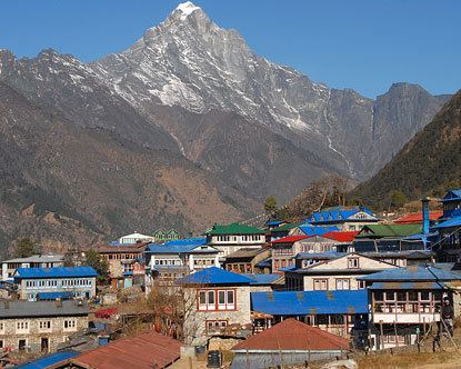
Lukla is a town in the Khumbu area of the Solukhumbu District in the Sagarmatha Zone of north-eastern Nepal. Situated at 2,860 metres (9,383 ft), it is a popular place for visitors to the Himalayas near Mount Everest to arrive. Although Lukla means place with many goats and sheep, few are found in the area these days.
Contents
- Trek from lukla to mount everest base camp nepal
- Map of Lukla Chaurikharka 56000 Nepal
- Airport
- References
Map of Lukla, Chaurikharka 56000, Nepal
Lukla contains a small airport servicing the region, and a variety of shops and lodges catering to tourists and trekkers, providing western-style meals and trail supplies.
From Lukla, travellers will take two days to reach the village Namche Bazaar, an altitude acclimatization stop for those continuing on.
In August 2014, the Nepalese government announced plans to open the first tarmac road from Kathmandu to Lukla.
Airport
Lukla is served by the Tenzing-Hillary Airport. Weather permitting, twin-engined Dornier Do 228s and de Havilland Canada Twin Otters make frequent daylight flights between Lukla and Kathmandu. Lukla Airport has a very short and steep airstrip, often compounded by hazardous weather, resulting in several fatal accidents. It has been called the most dangerous airport in the world.