
Airport type Public Elevation AMSL 98 ft / 30 m 11,301 3,445 Code MHR | 4R/22L 11,301 Elevation 29 m | |
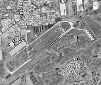 | ||
Sacramento Mather Airport (IATA: MHR, ICAO: KMHR, FAA LID: MHR), also known as simply Mather Airport, is a county-owned public-use airport located 10 nautical miles (19 km) east of the central business district of Sacramento, in Sacramento County, California, United States. It is located on the site of the former Mather Air Force Base which was closed in 1993.
Contents
Facilities and aircraft
Sacramento Mather Airport covers an area of 2,875 acres (1,163 ha) at an elevation of 99 feet (30 m) above mean sea level. It has two runways: 4L/22R is 6,040 by 150 feet (1,841 x 46 m) with an asphalt pavement; 4R/22L is 11,301 by 150 feet (3,445 x 46 m) with a concrete and asphalt surface. The airport also has two helipads: H1 is 30 x 30 ft. (9 x 9 m); H2 is 100 x 100 ft. (30 x 30 m).
For the 12-month period ending December 31, 2005, the airport had 101,000 aircraft operations, an average of 276 per day: 55% general aviation, 19% air taxi, 16% scheduled commercial and 10% military. At that time there were 152 aircraft based at this airport: 23% single-engine, 24% multi-engine, 2% jet, 24% helicopter and 27% military.
Incidents
On February 17, 2000 an Emery Worldwide DC-8 cargo plane crashed shortly after takeoff from this airport.