
Time zone CET/CEST (UTC+1/+2) Area 14.3 km² Population 674 (31 Dec 2008) Dialling code 05355 | Elevation 114 m (374 ft) Postal codes 38376 Local time Tuesday 4:00 PM Postal code 38376 | |
 | ||
Weather 12°C, Wind NE at 10 km/h, 60% Humidity | ||
Süpplingenburg is a municipality of 700 inhabitants (2003) in the district of Helmstedt, Lower Saxony, Germany. It is part of the collective municipality (Samtgemeinde) of Nord-Elm.
Contents
Map of 38376 S%C3%BCpplingenburg, Germany
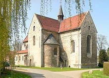
The village developed next to a 10th-century water castle at the Schunter river, probably erected by the Counts of Haldensleben who then held the office of margraves of the Northern March. Gertrud von Haldensleben's daughter, Hedwig of Formbach, married Count Gebhard of Supplinburg. Until 1173 the castle was the seat of the Counts of Supplinburg, among them Gebhard's son Emperor Lothair III of Supplinburg.
Lothair had a collegiate church and cloister built within the Supplinburg palace about 1130. In 1173 his grandson Henry the Lion granted Süpplingenburg to the Knights Templar order, from which it fell to the Knights Hospitaller in 1357. It remained a commandry (Komturei) of the Order of Saint John until in 1820 it was finally mediatised to the Duchy of Brunswick. The castle was demolished about 1875, while the St John Church survived, today a stop at the scenic Romanesque Road.
Transportation
Süpplingenburg can be reached via the Bundesstraße 1 federal highway at Süpplingen or the Bundesautobahn 2 at the Rennau junction. Train service of the Brunswick-Magdeburg railway line is available at Helmstedt.