
District Sørlandet Area rank 356 in Norway Area 151.3 km² Local time Tuesday 2:22 PM | Demonym(s) Søgnesokning Population 11,260 (2016) | |
 | ||
Weather 7°C, Wind S at 14 km/h, 95% Humidity | ||
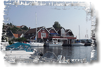
Søgne is a municipality in Vest-Agder county, Norway. It is located in the traditional district of Sørlandet. The administrative centre of the municipality is the village of Tangvall. Other villages in Søgne include Ausviga, Eig, Høllen, Langenes, Lohne, Lunde, Ny-Hellesund, Trysnes, Vedderheia, Ålo, and Åros.
Contents
- Map of 4640 SC3B8gne Norway
- General information
- Name
- Coat of arms
- Churches
- Government
- Municipal council
- Geography
- References
Map of 4640 S%C3%B8gne, Norway
General information
The parish of Sygne (later spelled Søgne) was established as a municipality on 1 January 1838 (see formannskapsdistrikt). on 1 July 1913, the northern half of Søgne (population: 822) was separated to form the new municipality of Greipstad. This left Søgne with 2,609 residents. During the 1960s, there were many municipal mergers across Norway due to the work of the Schei Committee. Søgne municipality remained generally the same during this time, however, there were a couple of small changes to the municipal boundaries. On 1 January 1964, the Stubstad area of neighboring Holum municipality (population: 9) and the Brunvatne area of neighboring Øyslebø municipality (population: 44) were both transferred to Søgne municipality. Then on 1 January 1965, the unpopulated Svalemyren area of neighboring Mandal municipality was transferred to Søgne.
Name
The municipality (originally the parish) is named after the old Søgne farm (Old Norse: Sygna), since the Old Søgne Church was built there. The farm is named after the river Sygna (now called Søgneelva) and the name of the river is derived from the verb súga which means "suck". The municipality was historically spelled Sygne until the late 1800s.
Coat-of-arms
The coat-of-arms is from modern times; they were granted on 24 May 1985. The blue and silver/white arms show two stone road signs (varder), which in historical times were used to mark the paths and tracks. Two of the largest of these signs are found in the municipality, and were mentioned in historical records in the early 17th century. According to legend, they were already built by King Olaf II of Norway (Hellige-Olav), in the 11th century.
Churches
The Church of Norway has one parish (sokn) within the municipality of Søgne. It is part of the Mandal deanery in the Diocese of Agder og Telemark.
Government
All municipalities in Norway, including Søgne, are responsible for primary education (through 10th grade), outpatient health services, senior citizen services, unemployment and other social services, zoning, economic development, and municipal roads. The municipality is governed by a municipal council of elected representatives, which in turn elect a mayor.
Municipal council
The municipal council (Kommunestyre) of Søgne is made up of 27 representatives that are elected to every four years. Currently, the party breakdown is as follows:
Geography
Søgne is a small, coastal municipality, with a long stretch of coastline and islands to the south. To the east, it borders the municipality of Kristiansand, to the north and northeast it borders the municipalities of Marnardal and Songdalen, and to the west it borders the municipality of Mandal.
The municipality has a couple main rivers running through it: Lundeelva and Søgneelva. The Trysfjorden cuts into the shoreline in the west part of the municipality. There are also many islands to the south of the mainland. Ny-Hellesund is a small cluster of three populated islands that were an important outport in the history of Søgne. The Songvår Lighthouse is located in the far south part of the municipality on the small island of Hellersøya.