
County Vest-Agder Area 5.87 km² Local time Sunday 3:56 PM | Elevation 16 m (52 ft) Population 9,147 (2015) | |
 | ||
Weather 16°C, Wind SW at 11 km/h, 56% Humidity | ||
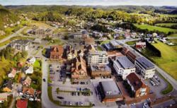
Tangvall is the administrative centre of Søgne municipality in Vest-Agder county, Norway. The village is located along the European route E39 highway and the river Søgneelva. The village sits just north of Åros and Høllen, northeast of the village of Eig, and east of the village of Lunde.
Map of 4640 Tangvall, Norway
Together, Tangvall, Lunde, Høllen, Eig, Åros, and Langenes all form one large urban area known as Søgne. The 5.87-square-kilometre (1,450-acre) urban area has a population (2015) of 9,147 a population density of 1,558 inhabitants per square kilometre (4,040/sq mi).
The Old Søgne Church is located in the southeastern part of the urban area, just north of Åros and Langenes. The "new" Søgne Church is located in Lunde. The municipal government is based in Tangvall since 1974. Prior to that time, it was located in Lunde. The municipal high school is also located here.