
Season All year | ||
 | ||
Length 1,000 kilometres (620 mi) approximately Similar Roslagsleden, Paradiset, Nackareservatet, Läggesta railway station, Nynäs Castle | ||
Sörmlandsleden ("Sörmland trail")" is a system of hiking trails covering a total of approximately 1,000-kilometre (620 mi) of walking paths in Södermanland, south of Stockholm, Sweden.
Contents
Map of s%C3%B6rmlandsleden, 136 68 Vendels%C3%B6, Sweden
The trails pass through several nature reserves, areas of cultural tradition and several historical monuments.
The trail
The trail begins in Björkhagen, Stockholm and passes through several places like Stockholm, Nynäshamn, Södertälje, Trosa, Nyköping, Oxelösund, Katrineholm, Hälleforsnäs and Malmköping. It also has several branches that go to places like Flen, Eskilstuna, Gnesta and Mariefred.
The trails passes through Tyresta National Park, Nackareservatet, Paradiset Nature Reserve, Stora Träsket Nature Reserve, Linudden Nature Reserve, Stora Bötet Nature Reserve, Strandstuviken Nature Reserve and Tullgarn Nature Reserve.
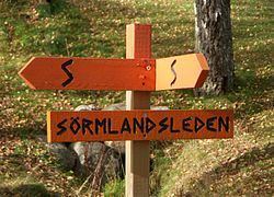
The trail marking is with orange coloured rings around trees or pole and signs with symbols or the letter "S" with orange background. The trails pass through several sorts of terrain with different grade of difficulty.
Along the trails are rest areas, lean-to, campsites, log cabins and other shelters. There are several springs to refill with drinking water.
The trails are divided over 100 sections. The length of a section variate between 3 and 17 km (11 mi), most common around 10 km (6 mi).