
Country Brazil Time zone UTC-3 (UTC-3) Population 83,020 (2015) | Settled March 16, 1636 Area 403,336 km² Local time Tuesday 4:41 AM | |
 | ||
Metropolitan Region Vale do Paraíba e Litoral Norte Weather 23°C, Wind NE at 10 km/h, 84% Humidity Points of interest Juqueí, Maresias, Guaecá, Praia Preta, Barra do Saí | ||
São Sebastião (Portuguese for Saint Sebastian) is a Brazilian municipality, located on the southeast coast of Brazil, in the state of São Paulo. The population in 2009 was 76,344, its density was 182.5/km² and the area is 403 km². The Tropic of Capricorn lies 25 km north. The municipality existed since 1636 and formed a part of the old hereditary captaincy of Santo Amaro.
Contents
- Map of SC3A3o SebastiC3A3o State of SC3A3o Paulo Brazil
- History
- Geography
- Islands
- Toque Toque Islands
- Alcatrazes Islands
- As Ilhas
- Gatos Island
- Couves Island
- Monto de Trigo Island
- Economy
- Sites of interest
- Beaches
- Transportation
- Famous Sebastianenses
- Sister city
- References
Map of S%C3%A3o Sebasti%C3%A3o, State of S%C3%A3o Paulo, Brazil
The archipelago municipality of Ilhabela is located on the east coast of the city; the largest island of the archipelago is also called São Sebastião. Between the city and the island, there is the São Sebastião channel with 30 kilometres in length, and variable width (2 km being the shortest crossing). There is an oil terminal at the channel, owned by Transpetro, a subsidiary of Petrobrás.
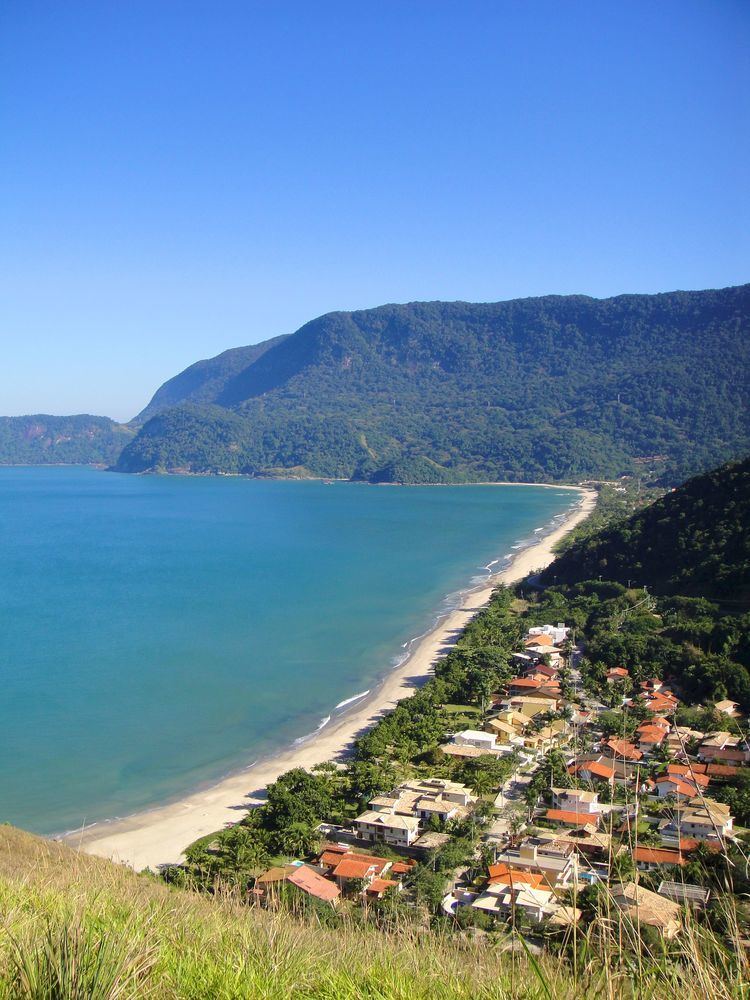
The city is famous for its beaches, which makes it a popular tourism destination, especially for people from the state of São Paulo. Near the boundary with Bertioga, there is a small Guarani village managed by FUNAI.
History
Before the Portuguese first arrived, the area was inhabited by the Tupinambás to the north and the Tupiniquins to the south. Both tribes were separated by the Serra de Boiçucanga (Boiçucanga Mountain range), located 30 km south of the city centre. Both tribes disliked each other. When the French arrived in Brazil via the Guanabara Bay and confronted the Portuguese, the Tupiniquins united with the Portuguese and the Tupinambás, with the French. This battle between them was witnessed and narrated by Hans Staden.
The municipality was named after Saint Sebastian because of the day that the Américo Vespúcio expedition sailed through the channel between the city and Ilhabela – January 20, 1502.
The first Portuguese to settle there were Diogo de Unhate, Diogo Dias, João de Abreu, Gonçalo Pedroso and Francisco de Escobar Ortiz, just after the division of Brazil in capitanias hereditárias. São Sebastião was part of the Captaincy of Santo Amaro. The place was first developed as an agriculture and fishing village. The agricultural activities transformed the village in a major sugar cane producer, which later helped the hamlet to earn its village status on March 16, 1636. To gain this status, though, the village had to build a church in honour of Saint Sebastian.
A few years after this, another hamlet developed just north of São Sebastião: São Francisco da Praia (Saint Francis of the Beach). In 1840, the hamlet took the first step to become independent: they asked it to become a freguesia. The request was eventually accepted in the same year, but the freguesia was disestablished in 1859 and re-joined to São Sebastião.
The city kept on basing its economy on the production of sugar cane, coffea, tobacco and fishing. The local port was widely used to load ships with gold from Minas Gerais during the 17th and 18th centuries. It was also used by pirates and smugglers.
When slavery was abolished, in 1888, and the railway linking São Paulo to the bigger Port of Santos was opened, the city's economy entered a period of crisis, and the population decreased. From that moment on, the city began to rely on subsistence agriculture and "handicraft fishing" (Pesca Artesanal), a type of fishing done entirely by hand since the fishing until the consumption (in other words, no machinery is used, and most of the people who practice it do it for subsistence as well).
Until the 1960s, nothing much has changed. However, in that decade, Petrobras built its oil terminal, attracting new employees and investments. The occupation of the city became wider and faster. While the city centre kept its development, workers from other parts of Brazil built their houses near the Serra do Mar, originating the neighborhood of Topolândia, which now concentrates the lower-class families.
São Sebastião became a tourist destination in the late 1980s, when the Rodovia Rio-Santos (a section of the BR-101 that connects Santos to Rio de Janeiro) was completed and paved. Most of the lands were sold to countryside or paulistanas families who wished a house to spend the weekends and holidays. Most of the caiçaras (people who make a living out of fishing) started to work with tourism, even though a few of them still earn money from fishing.
Until nowadays, tourism plays an important role in the city's economy. However, as the city grew, proper water and sewage pipes have not been built for every building, which led to the lack of proper urban infrastructure in certain points of the city. As of November 2010, less than 50% of the city's sewage receives proper treatment. However, after a project by the government of the state os São Paulo called "Onda Limpa" (Clean Wave), the percentage of houses connected to sewage pipes went up to 94%, as of January 2012.
Besides, improper housing became a major problem, as more houses are built in Mata Atlântica zones which, apart from being subject to preservation, are highly likely to suffer from mudslides. There is an estimated 11,045 houses built in "frozen" areas, that is, areas in which new houses are not allowed to be built. The number of new buildings in the region grows 20% every year.
Another current threat to the city is the sea level rise, which may affect several beaches and buildings located close the shore.
On March 2012, the deputy mayor of São Sebastião, Wagner Teixeira (PV) was caught committing illegal fishing off the coast of the city, near Paredão Island, Alcatrezes Archipelago. He was at his personal boat with five more men, and didn't stop until his engine ran out of oil, even with the coast guard on his tail with the sirens on. He was carrying 116 kg of fish, including endangered species, and stated he wasn't aware of the prohibition of fishing in that area.
The Port of São Sebastião will receive considerable investments in the next years so that it increases its operation capacity in a long reform that should last until 2035. The number of employees at the port is expected to jump from the current 450 to 4500, 2/3 of them being necessarily local. Another improvement expected for the next years (tentatively 2016) is the duplication of Tamoios Highway, which connects São José dos Campos and the neighbor city of Caraguatatuba and is the main way towards the city for people coming from São Paulo and many other cities.
Geography
Virtually everything of the city is located at the narrow plains between the Atlantic Ocean and the mountains, except for some cell phone towers and transmission towers. In the central portion of the city, these plains are never wider than 3 km, although they may measure up to 6 km in the less developed areas to the west. Most of the city concentrates between the Enseada Beach (the last before Caraguatatuba) and the Guaecá Beach. From Toque Toque Grande beach to Boracéia Beach (the last before Bertioga), hotels, summer houses and nightclubs dominate the plains. The Guaratuba River marks the border with Bertioga, while the Juqueriquerê River marks the border with Caraguatatuba.
The city has an oceanic climate, with an annual average temperature of 24 °C. Most of the mountainous terrain and the islands are covered with the Atlantic Forest.
Two districts make up the municipality: São Sebastião District (Distrito de São Sebastião) and Maresias District (Distrito de Maresias).
Islands
There are a number of islands spread all over the city's coastline, all of them created by ancient volcanic activities. The largest and most famous is the Ilha de São Sebastião (São Sebastião Island), which is part of the municipality of Ilhabela.
Toque-Toque Islands
From north to south, the Toque-Toque Grande island is the first after Ilhabela, and is located in front of the beach of same name. There are neither beaches nor people there, but the place is visited for scubadiving. The nearby Toque-Toque Pequeno Island is smaller, and resembles a turtle when seen from the Santiago Beach.
Alcatrazes Islands
The Alcatrazes Archipelago is formed by five bigger islands (Alcatrazes Island, Sapata Island, Paredão Island, Porto Island (aka Farol Island) and Southern island), and some smaller unnamed islands. It is the farthest island of São Sebastião, being some 30 km (18.6 mi) away from the southern tip of Ilhabela and 35 km (21.7 mi) from the nearest continent beach, Boiçucanga. Several birds, whales and other sea animals stop there seasonally to reproduce. The main island was once used by the Brazilian Navy as a howitzer shooting exercise point. As the shots were harming the environment of the island (either because of the noise, either because of the impacts), the Brazilian Navy quit exercising. However, the island is still ruled by the military, who forbid fishing, diving and visiting on the island, except for researchers. The islands are within the Tupinambás Ecological Station.
As Ilhas
Despite its name (which means The Islands), As Ilhas are actually formed by one island only. It differs from other islands because there's a beach there, which is frequently visited by tourists from the nearby Barra do Saí and Juqueí beaches, both located around 2.4 km (1.5 mi) from the island.
Gatos Island
The Ilha dos Gatos (Cats Island, located 1.8 km (1.1 mi) from the Ponta da Baleia (Whale Edge), a hill between the Camburi Beach and da Baleia Beach) is an island open for public visitation. It is told that it was once owned by an associate to the Rockefeller family, and that the ruins on top of its hills are from a mansion Rockefeller himself tried to have built, but that was embargoed by the Brazilian government. It is adequate for freediving. The waters surrounding Gatos Island are full of snooks, and they are also frequently visited by whales during the winter.
Couves Island
Ilha das Couves (Cabbages Island, located 2.4 km (1.5 mi) from the coast and mere 600 m (1,920 ft) south of As Ilhas) is accessible from Barra do Sahy, via boats that are run by a fisherman's cooperative. Local grassroots efforts are under way to create an ecotourism educational center focusing on sustainable living. It also has some ruins on top of it: a small hotel started in 2008, but also embargoed by the Brazilian Navy.
Montão de Trigo Island
The Ilha Montão de Trigo lies 10 km (8.7 mi) south of the nearest beach (Barra do Una). The highest point of the island is at 276 m AMSL. For the last three centuries, it had been permanently inhabited by families of caiçaras (circa 52 as of January 2012), who have been recently granted official permission to occupy and explore the island, which still belongs to the government, but will no longer be available for any possible future real estate companies projects. The permission is part of a series of actions taken by the federal government in order to benefit small traditional populations throughout the country. The permissions are called TAUS - Termo de Autorização de Uso Sustentável (Term of Authorization of Sustainable Use). This is the first time an island population earned such permission, since they are mostly given to people living near rivers in Northern Brazil. With the TAUS, the caiçaras can demand improvements such as proper housing, sanitation and water systems.
The local population lives with little infrastructure: there is no electricity, only one school which teaches until the 4th grade, and an improvised pier is the only way into the beachless island. No doctor has been there in the last two years. Due to most of the weddings occurring within the same family, most of the inhabitants share the Oliveira surname.
Economy
As of 2005, the city has a GDP of R$1,107,595,000.00 and a GDP per capita of R$15,138.
Sites of interest
Apart from its 36 beaches (see below), the city has a few places to visit, like the Igreja Matriz de São Sebastião, the Museu de Arte Sacra (Sacred Art Museum), the Convento da Nossa Senhora do Amparo and the Convento Franciscano. The city centre can be divided in two parts. One of them is located around the Igreja Matriz, and is filled with houses from the colonial period, most of them containing bars, hotels and restaurants. The other part is located near the sea, and concentrates most of the nightlife. There is a number of bars and ice cream shops, a handicraft fair and a large leisure square, which includes the largest skatepark in Brazil, measuring 7,000m².
Beaches
There are 36 beaches throughout the more than 100 km (63 mi) of coast of the city. From North to South:
Transportation
The only way to access the city is via the BR-101, called Avenue Dr. Manoel Hipólito do Rego in the central portion of the city and Prestes Maia Highway on the rest of the city. It is possible to come from Caraguatatuba to the north or Bertioga to the south. The highway is the most important road of the city, connecting it from north to south, and having a regular bus line running all through it. Bicycles are also widely used in the city.
Famous Sebastianenses
Sister city
São Sebastião has one sister city designated by Sister Cities International: