
Elevation 744 m (2,441 ft) Area 15.33 km² | Region Southeast Brazil Time zone BRT (UTC-3) Population 149,263 (2010) | |
 | ||
Weather 19°C, Wind SE at 11 km/h, 82% Humidity Colleges and Universities Universidade Municipal de São C, Instituto Mauá de Tecnologia, Grande ABC University | ||
São Caetano do Sul (or São Caetano) is a city in São Paulo state in Brazil. It is part of the Metropolitan Region of São Paulo. The population is 158,024 (2015 est.) in an area of 15.33 km². It is the city with the highest per capita income in Brazil (US$31,322.00 in 2010) and it also has the highest Human Development Index.
Contents
- Map of SC3A3o Caetano do Sul State of SC3A3o Paulo Brazil
- Geography
- Climate
- The Best Standard of Living in Brazil
- Demographics
- Access to domestic goods of population
- Higher education
- References
Map of S%C3%A3o Caetano do Sul, State of S%C3%A3o Paulo, Brazil
Geography
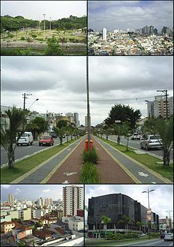
São Caetano do Sul is located on a plateau that is part of the Serra do Mar (Portuguese for "Sea Range"), part of the vast region known as the Brazilian Highlands, with an average elevation of around 800 meters (2,600 ft) above sea level – though at a distance of only about 70 kilometers (43 mi) from the Atlantic Ocean. Neighbouring municipalities are Santo André (East and South), São Bernardo do Campo (West) and São Paulo (North).
Climate
According to the Köppen climate classification São Caetano do Sul has a humid subtropical climate.
The Best Standard of Living in Brazil
São Caetano do Sul boasts the highest social indicators anywhere in the country (even if using indexes such as those that compute the HDI formula). Illiteracy rates are very low and most people enjoy a safe city with well-maintained infrastructure. São Caetano has no favelas, with the closest one bordering Heliópolis, São Paulo’s largest favela, next to a large Petrobras oil distribution and storage facility in nearby Ipiranga. Such border areas between São Caetano and adjacent cities São Bernardo do Campo and Santo André are prone to flooding which happens often, especially in the more impoverished areas bordering the city of São Paulo, where the Meninos creek (a tributary of the heavily polluted Tamanduateí river) is often littered with construction debris and garbage, exacerbating the flooding effect in the rainy season (Oct–Feb).
The city is served by a comprehensive network of bus routes that also connects São Caetano to its neighboring towns. There is also one commuter train line (operated by CPTM) that connects the city to São Paulo and its neighbors to the south, Santo André and Mauá.
Demographics
Immigrants from many nationalities have settled in São Caetano but the most significant groups are Italians, Spaniards, Portuguese, Germans and Japanese. In the 1950s, nationals from rural Northeastern Brazil started arriving as the region experienced a rapid industrialization boom.