
District Rwamagana District Elevation 1,528 m Local time Saturday 1:13 PM | Climate Aw Area 87 km² Population 47,203 (2015) | |
 | ||
Weather 22°C, Wind E at 23 km/h, 66% Humidity | ||
Rwamagana is a city and capital of both Rwamagana district and the Eastern Province of Rwanda
Contents
Map of Rwamagana, Rwanda
Jordons week 1 4 rwamagana rwanda tearfund ics
Description
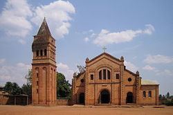
Rwamagana lies approximately 50 km (31 mi) from Kigali, on the newly renovated road leading east towards Tanzania. There was formerly a large amount of traffic running through the centre, particularly freight to and from Tanzania, but with the recent creation of a bypass, the centre of the city is now quieter. The city lies mainly along two roads, the main east-west route, and a spur leading off to the south. The main market and the Banque de Kigali are on this spur, while the city's two petrol stations, taxi-bus parks and post office are on the east-west road. There is a large church at the western end of the city, adjacent to the main secondary school, and a new conference centre at the eastern end of the bypass. Rwamagana district has about 14 sectors including: Kigabiro, Muyumbu, Nyakariro, Karenge, Nzige, Gahengeri, Mwurire, Rubona, Gishari, Munyiginya, Muhazi, Gishari, Mushutu and Munyaga. Five leading commercial centres with modern market and central services in commercial industries are Rwamagana centre, Karenge centre, Nyagasambu centre, Rubona centre. Four coffee washing station in this district include: RWACOF at Karenge, KOPAKABI at Karenge, Muyumbu and Rubona washing stations are the major factory to prepare the coffee in the district.