
Country United States FIPS code 46-56820 Elevation 381 m Area code 605 | Time zone Central (CST) (UTC-6) GNIS feature ID 1257520 Area 5.4 km² | |
 | ||
Running Water is a census-designated place (CDP) in Bon Homme County, South Dakota, United States. The population was 36 at the 2010 census.
Contents
Map of Running Water, SD 57062, USA
The community's name Running Water is a former variant name of the nearby Niobrara River.
Geography
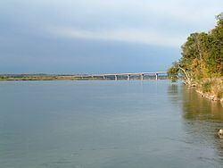
Running Water is located on the north side of the Missouri River in southern Bon Homme County along the South Dakota-Nebraska state line. South Dakota Highway 37 crosses the Missouri at Running Water, becoming Nebraska Highway 14 on the opposite shore. SD 37 leads north and east 10 miles (16 km) to Springfield, and NE 14 leads south and west 3 miles (5 km) to Niobrara.
According to the United States Census Bureau, the Running Water CDP has a total area of 2.1 square miles (5.4 km2), all of it land.
References
Running Water, South Dakota Wikipedia(Text) CC BY-SA