
Country Bahamas Established 1996 Elevation 37 m Population 53 (2015) | Island Rum Cay Time zone EST (UTC−5) Area 78 km² | |
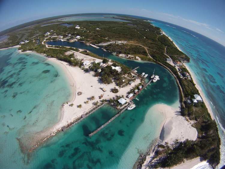 | ||
Rum cay bahamas
Rum Cay (formerly known as Mamana and Santa Maria de la Concepción) is an island and district of the Bahamas. It measures 30 square miles (78 km2) in area, it is located at Lat.: N23 42' 30" - Long.: W 74 50' 00". It has many rolling hills that rise to about 120 feet (37 m).
Contents
- Rum cay bahamas
- Map of Rum Cay The Bahamas
- Rum cay island bahamas
- LocationEdit
- AboriginalsEdit
- SpanishEdit
- LoyalistsEdit
- TodayEdit
- Places of interestEdit
- HMS ConquerorEdit
- TransportationEdit
- References
Map of Rum Cay, The Bahamas
The island is believed to have acquired its modern name from a shipwrecked cargo of rum. The main settlement is Port Nelson. Its population was recorded as 99 as of 2010 and as 30 as of 2013. Before 1996 the island was part of a combined district of San Salvador and Rum Cay. The population of Rum Cay of 2015 is 53.
Rum cay island bahamas
LocationEdit
Rum Cay is 20 miles (32 km) southwest of San Salvador Island.
AboriginalsEdit
Rum Cay was called Mamana by the native Lucayans. In the north there is a cave containing Lucayan drawings and carvings. Various artifacts from the Arawak period have been found by farmers in the fertile soil, which the natives enriched with bat guano.
SpanishEdit
Rum Cay is believed to be the second island that Columbus visited in 1492, which he called Santa Maria de la Concepción. Spanish explorers once found a lone rum keg washed up on a shore and changed the name again to Rum Cay.
LoyalistsEdit
Plantation boundaries known as ‘margins’ can be seen all over the island, which date from the beginning of the 19th century when Loyalists settled here. In common with other islands, Rum Cay has gone through a series of industry specific economic peaks. Pineapple, salt and sisal have all been important industries, but competition and natural disasters, such as the 1926 hurricane, have all taken their toll. Settlements such as Port Boyd, Black Rock and Gin Hill are now deserted and overgrown.
TodayEdit
Tourism has traditionally been the main source of employment. Nearly everybody lives in Port Nelson where cottages can be rented.
Places of interestEdit
Deep reefs and drop-offs surround this former pirates’ haven. There is staghorn coral at Summer Point Reef and diving at Pinder’s Point. At the Grand Canyon, 60-foot coral walls almost reach the surface. Sumner Point Marina has dockage, fuel, moorings, WiFi, bar and restaurant. As of summer 2013, this marina is closed, and has only dockage available but absolutely no services.
HMS ConquerorEdit
The wreck of the 101-gun man of war HMS Conqueror, built in Devon in 1855 and which served in the Crimean War, lies in 30 feet of water off Rum Cay. She was lost on Sumner Point Reef, Rum Cay, on December 13, 1861. All 1,400 aboard survived. The wreck is preserved as the Underwater Museum of the Bahamas. It is the property of The Bahamas Government and none of the contents of the ship may be removed.
"She was 20 nm out in estimating her position and, after making her landfall, cut rounding the southeast point of Rum Cay too fine and went hard on the reef. Her captain, fearing that his crew (most of whom could not swim in those days) would drink themselves insensible when it became obvious the ship was lost, ordered all ale, wine, and spirit casks to be broken and their contents ditched. He then sent the two largest ship’s company unloaded everything they could salvage, and set about making a camp on the island. The captain remained on board with one midshipman and ten seamen until the ship broke up. Then all of them, less the boat parties, were marooned on Rum Cay. They were rescued soon after the news of the disaster was known."TransportationEdit
The island is served by Port Nelson Airport.