
 | ||
Alternate name Rogem Hiri, Galgal Refaim Similar Khirbet Kerak, Nimrod Fortress, Golan Archaeological Museum, Umm el Kanatir, Banias | ||
Rujm el hiri golan heights israel 23 04 2016
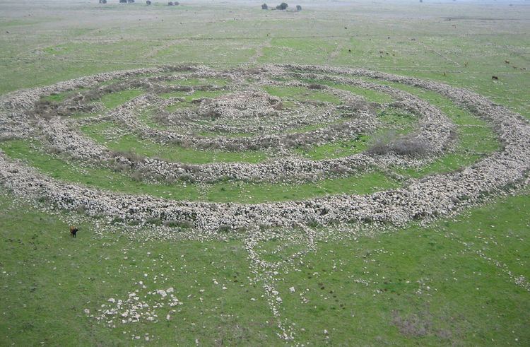
Rujm el-Hiri (Arabic: رجم الهري, Rujm al-Hīrī; Hebrew: גִּלְגַּל רְפָאִים Gilgal Refā'īm or Rogem Hiri) is an ancient megalithic monument, consisting of concentric circles of stone with a tumulus at center. It is located in the Israeli-occupied portion of the Golan Heights, some 16 kilometers east of the coast of the Sea of Galilee, in the middle of a large plateau covered with hundreds of dolmen.
Contents
- Rujm el hiri golan heights israel 23 04 2016
- Etymology
- Structure and description
- History and purpose
- Hypotheses
- Today
- References
Made up of more than 42,000 basalt rocks arranged in concentric circles, it has a mound 15 feet (4.6 m) tall at its center. Some circles are complete, others incomplete. The outermost wall is 520 feet (160 m) in diameter and 8 feet (2.4 m) high. The establishment of the site, and other nearby ancient settlements, is dated by archaeologists to the Early Bronze Age II period (3000–2700 BCE).
Since excavations have yielded very few material remains, Israeli archeologists theorize that the site was not a defensive position or a residential quarter but most likely a ritual center, possibly linked to the cult of the dead. However, there is no consensus regarding its function, as no similar structure has been found in the Near East.
Etymology
The name Rujm el-Hiri, "stone heap of the wild cat", appears on Syrian maps. The term rujm in Arabic (pl. rujum; Hebrew: rogem) can also refer to a tumulus, a heap of stones underneath which human burial space was located. The name is sometimes romanized as Rujm Hiri or Rujum al-Hiri.
Rogem Hiri is a Hebrew version of the Arabic name Rujm el-Hiri. A modern name used for the site is Gilgal Refā'īm or Galgal Refā'īm, "Wheel of Spirits" or "Wheel of Ghosts" as Refa'im in modern Hebrew means "ghosts" or "spirits". The same root underlies the word used in the Tanakh to refer to a race of giants, the Rephaites, described as the ancient people of Bashan (modern Golan).
Structure and description
The site's size and location, on a wide plateau which is also scattered with hundreds of dolmens, means that an aerial perspective is necessary to see the complete layout. The site was made from Basalt rocks, common in the Golan Heights due to the region's history of volcanic activity. It is made from 37,500 - 40,000 tons of partly worked stone stacked up to 2 meters (6.6 ft) high. It was estimated by Freikman that the transportation and building of the massive monument would have required more than 25,000 working days. The site is often referred to as the "Stonehenge of the Levant."
The remains consist of a large circle (slightly oval) of basalt rocks, containing four smaller concentric circles, each getting progressively thinner; some are complete, others incomplete. The walls of the circles are connected by irregularly placed smaller stone walls perpendicular to the circles.
The central tumulus is built from smaller rocks, and is thought to have been constructed after the surrounding walls were constructed. Connecting to it are four main stone walls. The first wall, shaped like a semicircle, is 50m in diameter and 1.5m wide. That wall is connected to a second one, an almost complete circle 90m in diameter. The third wall is a full circle, 110m in diameter and 2.6m wide. The fourth and outermost wall is the largest: 150m in diameter and 3.2m wide.
A central tumulus 65 feet (20 m) in diameter and 15 feet (4.6 m) high is surrounded by concentric circles, the outermost of which is 520 feet (160 m) in diameter and 8 feet (2.4 m) high. Two entrances to the site face the northeast (29 meters (95 ft) wide) and southeast (26 meters (85 ft) wide). The northeast entrance leads to an accessway 20 feet (6.1 m) long leading to the center of the circle which seems to point in the general direction of the June solstice sunrise. The axis of the tomb discovered at the site's center is similarly aligned. Mount Hermon is almost due north and Mount Tabor is close to December solstice sunrise. Geometry and astronomy are visually connected by the temple's design.
History and purpose
The site was cataloged during an archaeological survey carried out in 1967-1968 by Shmarya Gutman and Claire Epstein. The site is probably the source of the legends about "a remnant of the giants" or Rephaim for Og. The surveyors used Syrian maps, and a Syrian triangulation post was found on top of its cairn. After this initial study, serious archaeological excavations commenced in the 1980s under Israeli professors Moshe Kochavi and Yoni Mizrachi, as part of the Land of Geshur Archaeological Project.
Hypotheses
Today
In 2007, the site was excavated by Yosef Garfinkel and Michael Freikman of the Hebrew University of Jerusalem. Freikman returned in the summer of 2010 for further investigation of the site's date and function. Freikman believes that the tomb in the center was built at the same time as the rings. Tomb robbers looted the remains, which included jewelry and weapons, but based on the discovery of one Chalcolithic pin dropped in a passageway, Freikman's theory is that the tomb was the centerpiece of the rings.
New Age movements advocating a return to nature gather at the site on the summer solstice and on the equinox to view the first rays of the sun shine though the rocks.
The Golan Trail, a marked 130-kilometer walking trail that stretches along the whole length of the Golan Heights, passes Gilgal Refa'im.