
Villages none Time zone CET (UTC+1) Area 7.38 km² Team FC Ruggell | Elevation 433 m (1,421 ft) Postal code 9491 Area code 7010 | |
 | ||
Ruggell is the most northerly and low-lying of the Liechtenstein communities/municipalities, with population of 1,932 in 2007.
Contents
Map of Ruggell, 9491, Liechtenstein
History
The name is said to be from the Latin for "clearing the land" (roncale - ad roncalem). Most known for conservation areas and the historic St. Fridolin's Parish Church.
Geography
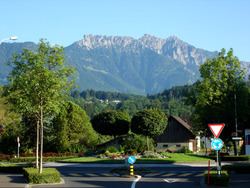
While Liechtenstein is known as a largely mountainous country, Ruggell is largely flat and is situated along the Rhine River, where the international borders with Switzerland and Austria meet.
References
Ruggell Wikipedia(Text) CC BY-SA