
Country United States Area code(s) 458 and 541 Elevation 42 m Zip code 97058 | Time zone Pacific (PST) (UTC-8) FIPS code 41-63950 Area 4.8 km² Population 187 (2010) | |
 | ||
Dash cam video of driving from rowena oregon to multnomah falls 46 miles
Rowena is an unincorporated community in Wasco County, Oregon, United States. For statistical purposes, the United States Census Bureau has defined Rowena as a census-designated place (CDP). The census definition of the area may not precisely correspond to local understanding of the area with the same name. The population was 187 at the 2010 census.
Contents
- Dash cam video of driving from rowena oregon to multnomah falls 46 miles
- Map of Rowena OR 97058 USA
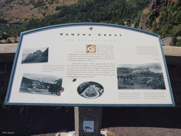
- 20100717 mosier the dalles hwy rowena oregon
- Geography
- Demographics
- References
Map of Rowena, OR 97058, USA
Rowena is located west of The Dalles on the Columbia River, where the river passes through the natural feature Rowena Gap. Interstate 84 (Columbia River Highway) and U.S. Route 30 (Historic Columbia River Highway) pass through the community. Route 30 near Rowena is notable for the Rowena Loops.
The origin of the name "Rowena" is disputed. Two sources say Rowena was named for H.S. Rowe, a railroad company official, in the early 1880s. Another source says it was named for a girl, Rowena, who had been living in the area at the time the community was founded. It is also possible that the name comes indirectly from Rowena, Ivanhoe's lover in the novel of the same name by Sir Walter Scott.
There was once a ferry operating between Rowena and Lyle, Washington across the Columbia.
The Nature Conservancy has a nature reserve on the plateau near Rowena, The Tom McCall Preserve known for its spring wildflowers. The preserve is owned and managed in cooperation with Mayer State Park.
20100717 mosier the dalles hwy rowena oregon
Geography
According to the United States Census Bureau, the CDP has a total area of 1.9 square miles (4.9 km2), all land.
Demographics
As of the census of 2010, there were 187 people, 77 households, and 51 families residing in the CDP. The population density was 98.4 people per square mile (30.7/km²). There were 111 housing units at an average density of 58.4 per square mile (123.1/km²). The racial makeup of the CDP was 97.9% White, 0.5% Asian, 0.5% Pacific Islander, 0.5% some other race, and 0.5% two or more races.
There were 77 households out of which 31.2% had children under the age of 18 living with them, 48.1% were married couples living together, and 33.8% were non-families. 27.3% of all households were made up of individuals and 22.1% had someone living alone who was 65 years of age or older. The average household size was 2.43 and the average family size was 2.86. The median age in the CDP was 41.2 years. Females made up 48.1% of the population and males made up 51.9%.