
Country United States FIPS code 53-40735 Elevation 62 m Zip code 98635 Area code Area code 509 | Time zone Pacific (PST) (UTC-8) GNIS feature ID 1512412 Area 8.8 km² Population 530 (2000) | |
 | ||
How to say or pronounce usa cities lyle washington
Lyle is a census-designated place (CDP) in Klickitat County, Washington, United States. The population was 530 at the 2000 census.
Contents
- How to say or pronounce usa cities lyle washington
- Map of Lyle WA 98635 USA
- History
- Lyle Today
- Geography
- Climate
- Demographics
- References
Map of Lyle, WA 98635, USA
History
Established around 1859, the original name of the community was Klickitat Landing. The first European settler was Egbert French, who arrived from Ohio. In 1866, French sold his holdings to James O. Lyle from The Dalles, Oregon, and moved to White Bluffs. After initially farming on the opposite shore (the Oregon side) for a few years, Lyle moved to the north bank of the Columbia.
A post office was soon established with Lyle as the first postmaster, and mail delivered by steamer from the opposite shore. Steamboat operation lasted until the North shore railroad was completed. When the Spokane, Portland and Seattle Railway came to town in 1907, its line passed somewhat north of the town. The present townsite was plotted in 1909, and the older townsite became known as 'downtown'. In 1941 there was a small airport in Lyle.
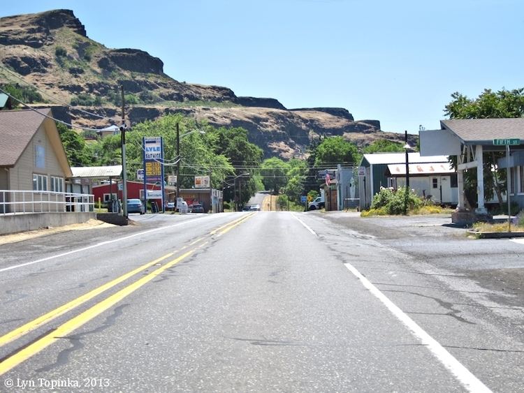
Lyle Today
Lyle has two main areas: that part which is built on the north banks of the Columbia River, including the "downtown," and that part which is built on the hills above the river. The downtown area has one grocery store (which is a super-sized quick-mart), two churches, a tavern, a restaurant/cafe, a gas station and vehicle repair shop, a second-hand store, an espresso stand, and a hotel. Other small businesses come and go, and all are located in the downtown area.
Residential areas flank downtown and extend east and west. Newer residences have sprung up on the northern hill overlooking downtown, with row upon row of homes on terraces. Less than 30 years ago, there were fewer than half a dozen homes on the entire hill. Now there are dozens, all seemingly vying for the best view of the Columbia River. Prices for hillside property are high for such a small town, and are based primarily on the view.
Although Lyle is 70+ miles east of Portland/Vancouver, it can be considered a bedroom community. The ease of freeway transportation on the "Oregon side" makes the commute a mere 60 minutes.
Because Lyle has no grade school, children of grade-school age are transported by bus to a school in Dallesport, an even smaller burg a few miles east of Lyle. The area's middle school and high school, which incorporate students from Dallesport and Murdock (also just east of Lyle) lie at the northernmost part of town, high on the hill overlooking Lyle. The student body is small and combines with nearby towns to make up teams for some sports.
Although tiny, somewhat rustic, and usually quiet, Lyle has attracted some attention because it lies very near several popular windsurfing beaches, including Doug's Beach. The area is also home to six boutique wineries: Cor Cellars, Domaine Pouillon, Jacob Williams Winery, Klickitat Canyon Winery, Memaloose, and Syncline.
Geography
Lyle is located at 45°41′45″N 121°16′56″W (45.695845, -121.282279).
According to the United States Census Bureau, the CDP has a total area of 3.4 square miles (8.8 km²), all of it land.
Climate
This region experiences warm (but not hot) and dry summers, with no average monthly temperatures above 71.6 °F. According to the Köppen Climate Classification system, Lyle has a warm-summer Mediterranean climate, abbreviated "Csb" on climate maps.
Demographics
As of the census of 2000, there were 530 people, 221 households, and 152 families residing in the CDP. The population density was 156.5 people per square mile (60.4/km²). There were 260 housing units at an average density of 76.8/sq mi (29.6/km²). The racial makeup of the CDP was 87.55% White, 1.89% Native American, 0.94% Asian, 0.38% Pacific Islander, 4.91% from other races, and 4.34% from two or more races. Hispanic or Latino of any race were 7.55% of the population.
There were 221 households out of which 31.7% had children under the age of 18 living with them, 51.6% were married couples living together, 13.1% had a female householder with no husband present, and 30.8% were non-families. 25.8% of all households were made up of individuals and 12.2% had someone living alone who was 65 years of age or older. The average household size was 2.34 and the average family size was 2.76.
In the CDP, the population was spread out with 26.8% under the age of 18, 7.4% from 18 to 24, 25.1% from 25 to 44, 25.3% from 45 to 64, and 15.5% who were 65 years of age or older. The median age was 41 years. For every 100 females there were 100.0 males. For every 100 females age 18 and over, there were 99.0 males.
The median income for a household in the CDP was $33,438, and the median income for a family was $40,083. Males had a median income of $37,292 versus $25,500 for females. The per capita income for the CDP was $17,355. About 8.1% of families and 11.6% of the population were below the poverty line, including 8.2% of those under age 18 and 20.6% of those age 65 or over.