
Area 6.25 ha (15.4 acres) State Tasmania Elevation 165 m | Adjacent bodies of water Southern Ocean Highest elevation 165 m (541 ft) Region South West Archipelago Maatsuyker Islands | |
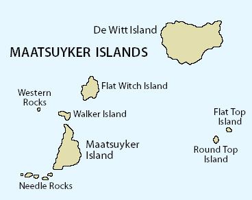 | ||
Round Top Island is an island located close to the south-western coast of Tasmania, Australia. The 6.25-hectare (0.0241 sq mi) island is part of the Maatsuyker Islands Group, and comprises part of the Southwest National Park and the Tasmanian Wilderness World Heritage Site.
Contents
Map of Round Top Island, Tasmania, Australia
The island's highest point is 165 metres (541 ft) above sea level.
Fauna
The island is part of the Maatsuyker Island Group Important Bird Area, identified as such by BirdLife International because of its importance as a breeding site for seabirds. Recorded breeding seabird species are the short-tailed shearwater (8900 pairs), fairy prion (9300 pairs), common diving-petrel (8700 pairs), Pacific gull and silver gull. The metallic skink and Tasmanian tree skink are present.
References
Round Top Island Wikipedia(Text) CC BY-SA