
Population 1,649 (2011 census) Civil parish Rotherfield Greys Area 7.73 km² Local time Thursday 5:26 AM Dialling code 01491 | OS grid reference SU725825 Sovereign state United Kingdom UK parliament constituency Henley | |
 | ||
Weather 6°C, Wind NE at 16 km/h, 93% Humidity | ||
Rotherfield Greys is a village and civil parish in the Chiltern Hills in South Oxfordshire. It is 2 miles (3 km) west of Henley-on-Thames and just over 1 mile (1.6 km) east of Rotherfield Peppard (locally known as Peppard). It is linked by a near-straight minor road to Henley.
Contents
Map of Rotherfield Greys, UK
History
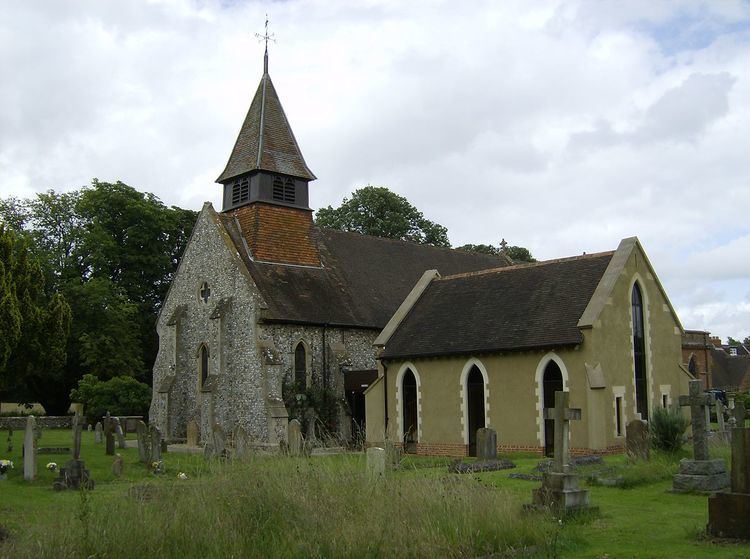
The Domesday Book of 1086 mentions Rotherfield Greys under the ownership of the Norman knight Anchetil de Greye and in a period when the county was administered in hundreds, in Binfield Hundred. Rotherfield derives from the Old English redrefeld meaning "cattle lands". The parish church includes the 16th-century Knollys Chapel, which houses an ornate tomb of the Knollys family. This includes effigies of Sir Francis Knollys and his wife, who was lady-in-waiting to Queen Elizabeth I.
Amenities
The Church of England parish church of Saint Nicholas is Norman and was restored in 1865.
The village has a public house, The Maltsters Arms, which is controlled by W.H. Brakspear & Sons.
Architecture
In the parish is Greys Court, whose predecessor was the manor house of the Grey family. It is owned and maintained by the National Trust and its Dower House is likewise in the top category of listed building, Grade I. As to other buildings, ruins and monuments 31 are listed in the parish for historic or architectural merit, most in the Grade II starting category.