
Area 678.5 km² Population 128,100 (2006) University Henley College | Constituent country England Founded 1 April 1974 | |
 | ||
Status Non-metropolitan district Points of interest Didcot Railway Centre, River Thames, Greys Court, River and Rowing Museum, Pendon Museum Destinations | ||
Shaping the future of south oxfordshire
South Oxfordshire is a local government district in Oxfordshire, England. Its council is based in Milton Park, Milton.
Contents
- Shaping the future of south oxfordshire
- Map of South Oxfordshire District UK
- Twenty seven fire crews respond to massive fire in south oxfordshire
- Geography
- Villages
- Energy policy
- Population change and distribution
- 2015 district council office fire
- References
Map of South Oxfordshire District, UK
The district was formed on 1 April 1974, under the Local Government Act 1972, from the municipal boroughs of Henley-on-Thames and Wallingford, Thame urban district, and Wallingford Rural District, Bullingdon Rural District and Henley Rural District. The Wallingford parts were previously part of the administrative county of Berkshire.
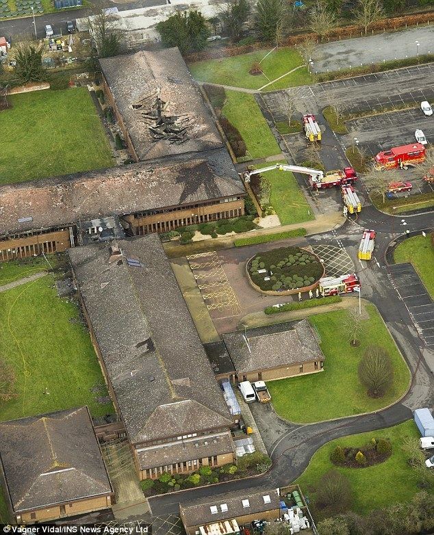
Twenty seven fire crews respond to massive fire in south oxfordshire
Geography
The River Thames flows for approximately 47 miles through South Oxfordshire and it is joined by the River Thame within the district. A characteristic of the rivers within the district is that they have wide floodplains with few houses on them so that fluvial flooding is a lesser problem than flash flooding. Towns in the district are Didcot, Henley-on-Thames, Thame, Wallingford and Watlington.
Villages
The larger villages in the district include:
See List of civil parishes in South Oxfordshire
Energy policy
In May 2006, a report commissioned by British Gas showed that housing in South Oxfordshire produced the 5th highest average carbon emissions in the country at 7,356 kg of carbon dioxide per dwelling.
Population change and distribution
The 2001 Census recorded a population of just over 128,000 in the district. This was an increase of 7% since 1991. Much of the district is rural in nature, with the land in agricultural use and around 70% of the district has a green belt or AONB designation (The northeast of the district forms part of the Oxford Green Belt). 50% of the district’s population lives outside its four main towns of Didcot, Henley, Thame and Wallingford.
2015 district council office fire
On 15 January 2015, an arson attack destroyed the district council main offices in Crowmarsh Gifford. As the fire started in the early hours of the morning there were no fatalities or injuries. Immediately after the fire, the council was temporarily based in Abingdon, in the neighbouring Vale of White Horse district. It has now moved to a semi-permanent base in Milton Park.