
First ascent 1873 | Elevation 3,002 m Mountains Kesselkogel | |
 | ||
Similar Dolomites, Latemar, Karersee, Fassa Valley, Marmolada | ||
Catinaccio rosengarten group
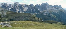
The Rosengarten group (Italian: Catinaccio [katiˈnattʃo], Ladin: Ciadenac, Ciadenáze) is a massif in the Dolomites of northern Italy. It is located between the Tierser Tal and Eggental in South Tyrol and the Fassa Valley in Trentino.
Contents
- Catinaccio rosengarten group
- Map of Rosengarten group 38036 Pozza di Fassa Province of Trento Italy
- SummitsEdit
- References
Map of Rosengarten group, 38036 Pozza di Fassa, Province of Trento, Italy
One peculiarity of the Rosengarten is the pink shade which, due to the presence of dolomite mineral, it takes in the sunset, celebrated in the Bozner Bergsteigerlied as "glowing". Meaning "Rose garden" in German, the name refers to the legend of King Laurin and his Rose Garden, a traditional story explaining the outer appearance of the mountain range.
Catinaccio rosengarten group
SummitsEdit
The highest peak is the Kesselkogel at 3,002 m (9,849 ft) over the sea level. Other peaks include:
References
Rosengarten group Wikipedia(Text) CC BY-SA