
- elevation 244 m (801 ft) - location Atlantic Ocean - urban .77 km (0 sq mi) Area 24.44 km² | - elevation 504 m (1,654 ft) - elevation 0 m (0 ft) - location Ribeira D'Agua Municipality Velas | |
 | ||
Rosais is a civil parish in the municipality of Velas in the Portuguese archipelago of the Azores. The population in 2011 was 743, in an area of 24.23 km².
Contents
Map of Rosais, Portugal
History
Rosais already existed as a parish since 1568, when the first documents started appearing. It was considered the barn for the island of São Jorge, due to its great fertility and, event today, supports rich pasturelands.
Geography
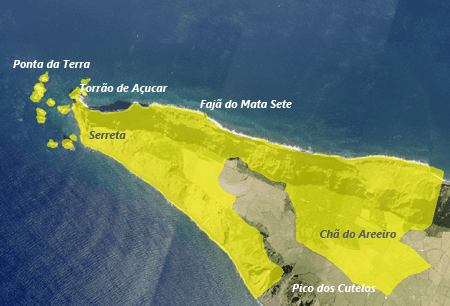
The parish of Rosais is located on the island of São Jorge and extends approximately 7 kilometres (4.3 mi) from Figueiras to Ponta, and approximately 820 inhabitants (2001 census).
The western corner of the island is essentially a plateau, with tall cliffs, until the Ponta dos Rosais, where the islands lighthouse stands as a beacon. The rest of the parish is pasture-lands and very small agglomerations, although the Parque Florestal das Sete Fontes breaks a portion of the territory. The Sete Fontes, which green-spaces and animal pens, realizes an annual festivals in honour of the emigrants that built the island.
Although many of the cliffs are sheer drops, there are some debris fields along the coast that give rise to the islands' fajãs. In particular is the Fajã de João Dias, located five minutes by foot from the cliff tops, a small enclave of buildings where many of the early settlers established homes.