
Highest elevation 1,158 m (3,799 ft) Population Uninhabited | Length 8 km (5 mi) Highest point Mount Britannia Elevation 1,158 m | |
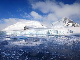 | ||
Rongé Island or Curville Island or De Rongé Island or Isla Curville or Rouge Island is a high, rugged island 8 km (5 mi) long, the largest island of the group which forms the west side of Errera Channel, off the west coast of Graham Land. Rongé Island is located at 64°43′S 62°41′W. Rongé Island was discovered by the Belgian Antarctic Expedition (1897–1899) under Adrien de Gerlache who named it for Madame de Rongé (cousin of Johannes Ronge), a contributor to the expedition.
Map of Rong%C3%A9 Island, Antarctica
References
Rongé Island Wikipedia(Text) CC BY-SA