
Year first constructed 1838 Automated 1966 Opened 1838 Construction Cast iron Added to NRHP 24 January 2007 | Year first lit 1898 (current tower) Height 16 m Range 27,780 m Material Cast iron | |
 | ||
Similar Old Orchard Shoal Light, West Bank Light, Prince's Bay Light, New Dorp Light, Point Aux Roches Light | ||
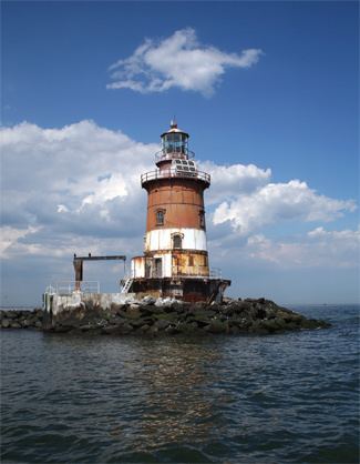
Romer Shoal Light is a sparkplug lighthouse in Lower New York Bay, on the north edge of the Swash Channel, about 3⁄4 nautical mile (1.4 km; 0.86 mi) south of Ambrose Channel and 2 1⁄2 nautical miles (4.6 km; 2.9 mi) north of Sandy Hook, New Jersey, in the entrance to New York Harbor. It is in New Jersey, very close to the border with New York.
Contents
- Map of Romer Shoal Light Beach 227th St New Jersey USA
- Sandy funds needed to restore historic romer shoal lighthouse
- References
Map of Romer Shoal Light, Beach 227th St, New Jersey, USA
The shoal was named for the pilot boat William J. Romer which sank there in 1863. The light was added to the National Register of Historic Places in 2007 as Romer Shoal Light Station.
The Light was badly damaged during Hurricane Sandy. The non-profit that has taken over stewardship of the Light is working with FEMA and private donors to save this national landmark.
Sandy funds needed to restore historic romer shoal lighthouse
References
Romer Shoal Light Wikipedia(Text) CC BY-SA