
Parent range Boring Lava Field NRHP Reference # 91001550 Area 9 ha Year built 1933 Added to NRHP 17 October 1991 | Topo map USGS Mount Tabor Elevation 187 m Prominence 123 m Mountain range Boring Lava Field | |
 | ||
Location Multnomah County, Oregon, U.S. Location Rocky Butte Rd. and parts of NE Fremont St. and 92nd Ave., Portland, Oregon Built by Multnomah Co. Road Dept. Similar Mount Tabor, Mount Talbert, Mount Scott, Larch Mountain, Mount Sylvania | ||
Rocky Butte is an extinct volcanic cinder cone butte in Portland, Oregon, United States. It is one of four, along with Kelly Butte, Powell Butte, and Mount Tabor, inside the city that are each home to a city park, Rocky Butte playing host to Joseph Wood Hill Park. A rotating beacon at the summit of the butte is visible for miles. It is also part of the Boring Lava Field, a group of over 30 cinder cones in Oregon and Washington. The slopes of Rocky Butte are also home of the Rocky Butte Natural Area. In addition, it was formerly home to Rocky Butte Jail and Judson Baptist College. Currently it is the location of a City Bible Church campus, Portland Bible College and City Christian Schools. It lies next to Interstate 205.
Contents
Map of Rocky Butte, Portland, OR 97220, USA
Formerly known as Wiberg Butte, a large quantity of rock was removed from the quarry on the east face of Rocky Butte in the 1940s for use in a new Multnomah County jail. After the jail was demolished in the 1980s, much of the stone was reused along the Historic Columbia River Highway. In the early 1900s, the Union Pacific Railroad had a spur into the east side of the Butte at a station named Quarry.
ClimbingEdit
Rocky Butte is a popular location for rock climbers in the Portland area. It hosts approximately 150 routes which vary in difficulty and type. The majority of routes will be top-roped, though there are some options for traditional climbing and lead climbing. The most popular climbs are on the section known as Video Bluff.
Hiking trailEdit
Rocky Butte does not have an official hiking trail. An unmarked primitive trail begins just east of The Grotto near the intersection of Skidmore Street and 92nd Avenue. The path ascends the butte mostly on the I-205 (east) side, through several vagrant campsites. The path goes under Rocky Butte Road near the Portland Bible Temple domes of the City Bible Church. From this point, a hiker can follow the paved road to the summit or search for the upper path. The upper path begins above the Portland Bible College campus, near an above-ground cistern surrounded by a chain-link fence. The upper path is even more primitive than the lower, to the point of essentially bushwhacking through blackberry vines all the way to the steps on the north slope of the summit. An alternative and more distinct upper trail connects the high side of the tunnel on Rocky Butte Road to the west slope of the summit. An apparent trail beginning at the end of Sacramento Street, east of 93rd Avenue, peters out after about 1 kilometre (0.62 mi).
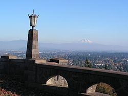
The summit of Rocky Butte is a Portland city park, Joseph Wood Hill Park. The summit is also noted on maps as Rocky Butte Natural Area, even though it is well developed. An Oregon state park, Rocky Butte State Park, lies mostly on the forested south and west slopes of the butte but does not have any official trails.
Rotating beaconEdit
The revolving beacon is inside the parapet wall. It was built in 1933 for the U.S. Bureau of Lighthouses as an aircraft navigation beacon and was outdated by the 1960s.