
Country Italy Demonym(s) Roccolani Population 1,045 (2009) | Elevation 437 m (1,434 ft) Time zone CET (UTC+1) Postal code 86078 Dialling code 0865 | |
 | ||
Roccapipirozzi is an Italian village, hamlet (frazione) of the municipality of Sesto Campano in the Province of Isernia, Molise. As of 2009 its population was of 1,045.
Contents
Map of 86078 Roccapipirozzi, Province of Isernia, Italy
History
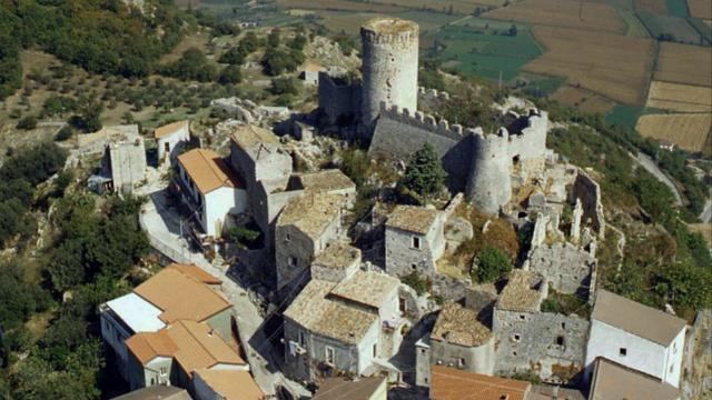
The village, founded by the refugees from Venafro, was first mentioned as Rocca Piperocii in the 13th century. The fortification and the old town are well preserved.
Geography
Roccapipirozzi, located near the borders with Lazio and Campania, lies into a valley below the mounts Cesima, Calvello and Sambucaro. It is 6 km far from Sesto Campano, 5 km from Venafro, 12 from San Pietro Infine, 26 from Isernia and 24 from Cassino. Nearest villages Vallecupa and Ceppagna, part of the municipality of Venafro.
The settlement is divided into 2 sides:
References
Roccapipirozzi Wikipedia(Text) CC BY-SA