
Area 99 ha (240 acres) | Location Bass Strait | |
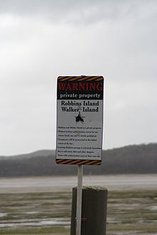 | ||
The Robbins Island is a 99-hectare (240-acre) island located in Bass Strait, lying off the northwest coast of Tasmania, Australia. The island, separated from the Tasmanian mainland by a highly tidal area known as Robbins Passage, lies south to the adjacent Walker Island.
Contents
- Map of Robbins Island Tasmania 7330 Australia
- History
- Topography and fauna
- Current developments
- References
Map of Robbins Island, Tasmania 7330, Australia
Robbins Islands is the seventh largest island of Tasmania and is the largest freehold island in Tasmania. Over the years Robbins Island has changed ownership and to this day remains privately owned.
History
The island was part of the territory of the indigenous North West tribe spanning from Table Cape to the western side of Macquarie Harbour, where in particular, the Parperloihener band resided on Robbins Island prior to European colonisation. On 23 November 1802, Charles Robbins, first mate of Buffalo was sent in Cumberland, by Governor King to dissuade the French commodore Nicholas Baudin, with his two ships Géographe and Naturaliste from colonising Van Diemen's Land.
Baudin had revealed French plans to colonise Van Diemen's Land when drunk in a farewell party organised by the Governor, after sailing into Port Jackson where his crew were treated back to health from scurvy. Governor King would not accept French occupation of Van Diemen's Land and chartered the schooner Cumberland to which in 13 December 1802, Robbins used successfully, persuading Baudin to abandon French settlement on Van Diemen's Land. The schooner was chartered as larger ships were away and used for other maritime activities. From there along with Charles Grimes, Robbins sailed to Port Phillip, and actively explored the Yarra River in 1803 before returning to Port Jackson. It was during a subsequent trip to retrieve two Spanish ships which had been captured by a NSW trader's privateering expedition and hidden off the coast of Deal Island that in 1804 Robbins discovered Robbins island, which is named after him.
In 1826, following the English occupation of Tasmania, the Van Diemen's Land Company was set up at Stanley. This company was formed in England by London-based businessmen, who wanted to utilise land in Tasmania to create a wool industry to supply the British textile industry, which intention was facilitated by William Sorrell's account to the Colonial Office that the Tasmanian colony was desperate for capital. The Van Diemen's Land Company Act was passed transferring possession of 250,000 acres (100,000 ha) of Crown land to freehold status or private ownership and included Robbins Island. A series of disputes during the period of 1820 to 1840, between European settlers and the North West tribe, in which Van Diemen's Land Company chief agent Edward Curr authorised the use of force if 'required', escalated into battles which became violent and bloody, notably including the infamous Cape Grim massacre. This culminated in the attempted genocide of what is now known as the Black War. In 1835 under George Robinson, almost all Indigenous people from the Tamanian mainland, including the Parperloihener band from Robbins Island, were removed and transported to a reserve on Flinders Island.
Topography and fauna
The island has a number of topographical features which include:
Current developments
The island was used by livestock to graze on, primarily for wool production before the 1850s. William B. Reid leased the island for 43 years commencing in 1873, where native animals on the land were used as wild game, farming and dairy products were made. Bill and Norah Holyman then bought the island in 1916 using it for sheep husbandry, selling off the island in 1958. In 1961, H E Hammond was the owner of the island, where it remains in family ownership today. His descendants, Keith and John Hammond currently produce on Robbins Island wagyū beef, which is exported to Japan. Commercial aquaculture industry from Circular Head presently harvest rock lobster and abalone in waters around the island. A wind farm has been proposed to be built on the island and was expected to be fully operational by 2014; yet by 2016 the wind farm had not been constructed.