
Population 3,120 (2011 census) Postcode(s) 2611 Area 160 ha Postal code 2611 | Established 1970 Founded 1970 | |
 | ||
Rivett (postcode: 2611) is a residential suburb of Canberra, Australian Capital Territory, Australia, established in the late 1960s. On Census night 2011, Rivett had a population of 3,120 people. It is situated on the western edge of the Weston Creek district.
Contents
Map of Rivett ACT 2611, Australia
Rivett takes its name from Sir (Albert Cherbury) David Rivett, KCMG; Rhodes Scholar 1907; Professor of Chemistry, Melbourne University, 1924–1927; Deputy Chairman and Chief Executive Officer, Council for Scientific and Industrial Research (CSIR), 1927–46; Chairman of the Council CSIRO, 1946–49; President of Australian and New Zealand Association for the Advancement of Science 1937-39.
Streets in Rivett are named after Australian flora.
Several homes in Rivett were burnt, and many residents evacuated during the 2003 Canberra bushfires.
Suburb amenities
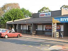
The Rivett local shopping centre is located at Rivett Place (off Bangalay Crescent). The centre contains a supermarket, newsagency, hairdresser, therapeutic masseuse and bakery.
Educational institutions located in Rivett are:
(a) Government schools -
(b) Non-government schools and colleges -
Churches located in Rivett are:
Health facilities located in Rivett are:
Public Transport located in Rivett are:
Rivett has extensive open spaces with playing fields on the western side of the suburb across from the shopping centre, several neighbourhood parks and pedestrian parkland weaving through the suburb.
Geology
Deakin Volcanics red-purple and green grey rhyodacite with spherulitic texture cover most of Rivett except for Laidlaw Volcanics grey tuff on the southernmost quarter. Quaternary alluvium covers the center.