
Basin size 87.3 km (33.7 sq mi) | Length 15 km Country United Kingdom | |
 | ||
Main source Watersheddles Reservoir, Lancashire329 metres (1,079 ft) River mouth River Aire, Keighley88 metres (289 ft) | ||
The River Worth is a river in West Yorkshire, England. It flows from minor tributaries on the moors above Watersheddles Reservoir down the Worth Valley to Haworth, where it is joined by Bridgehouse Beck which flows from Oxenhope. The River Worth is itself a tributary of the River Aire, which it joins at the end of the Worth Valley in Keighley.
Contents
- Map of River Worth United Kingdom
- Course
- Natural history
- History
- Leisure
- Tributaries
- Settlements
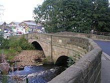
- Crossings
- References
Map of River Worth, United Kingdom
Course
There are many small streams that feed Watersheddles Reservoir (yards over the border in Lancashire) from which the River Worth is fed. From the reservoir, the river flows east into Ponden Reservoir into the town of Haworth where it is joined by Bridgehouse Beck. It then flows east north-east through the suburbs of Keighley into the town centre where north beck flows into it, it then continues down towards Stockbridge where it joins the River Aire. The typical river level range where it joins the River Aire is between 0.22 metres and 1.00 metres.
Natural history
The river was once very polluted, but the lack of local industry nowadays has seen the river become much cleaner and it supports many forms of wildlife throughout its course. Herons, kingfishers and dippers are now a common sight. The river currently has a population of small brown trout and grayling, but they are restricted to certain parts due to a number of high weirs which have been left behind from its industrial past.
History
The river provided power for the wool and clothing mills. Woollen and worsted manufacture was introduced here with the first cotton-mill erected in 1780.
Leisure
The river valley is home to the Keighley & Worth Valley Railway. Bradford City Council have marked out a short/middle (circular) distance walk along the valley called The Worth Way. Angling is also allowed by permit at certain places along the river.