Supriya Ghosh (Editor)

River Sett

Updated on
Edit
Like
Comment
Share on FacebookTweet on TwitterShare on LinkedInShare on Reddit
Tributaries
  
Mouth
  
Source
  
Country
  
United Kingdom

River Sett httpsuploadwikimediaorgwikipediacommonsthu

Main source
  
Kinder Scoutc.540 metres (1,770 ft)

River mouth
  
River Goytc.130 metres (430 ft)

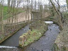
The River Sett is a river that flows through the High Peak borough of Derbyshire, in north western England. It rises near Edale Cross on Kinder Scout and flows through the villages of Hayfield and Birch Vale to join the River Goyt at New Mills. The River Goyt is one of the principal tributaries of the River Mersey.

Contents

Map of River Sett, United Kingdom

The 2.5-mile Sett Valley Trail follows the trackbed of the former railway line between Hayfield and New Mills.

Tributaries

  • Hidebank Brook ? (L)
  • Thornsett/Rowarth Brook ? (R)
  • Gibb Brook ? (L)
  • Raens Brook (L)
  • Birch Hall Brook ? (L)
  • Hollingworth Brook ? (R)
  • Middle Brook ? (L)
  • Phoside Brook ? (L)
  • Foxholes Brook (L)
  • Hazlehurst Brook (L)
  • River Kinder (R)
  • Upper Brook ? (L)
  • William Brook ? (R)
  • Blackshaws Brook ? (L)
  • Red Brook (L)
  • Coldwell Brook (R)
  • Dimpus Brook (L)
  • Oaken Brook (R)
  • References

    River Sett Wikipedia


    Similar Topics