
Native name Abhainn an Róba Basin area 320 km² Province Connacht | Length 63 km Mouth Lough Mask | |
 | ||
Basin size 320 square kilometres (120 sq mi) Discharge Average rate:0.267 m/s (9.4 cu ft/s) | ||
The River Robe (Irish: Abhainn an Róba) is a river in County Mayo, Ireland. It rises near Ballyhaunis, then flows generally west for 64 kilometres (40 mi), where it drains into Lough Mask.
Contents
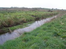
Map of Robe River, Co. Mayo, Ireland
The river's name in Irish is An Róba, first recorded as Rodba in medieval manuscripts.
The river is the longest tributary of Lough Mask and it drains 320 square kilometres of south Mayo. The total length of the river Robe's journey from its source near Ballyhaunis to Galway Bay (via Lough Mask, Cong canal and river, Lough Corrib and River Corrib) is 72 miles.
The Robe's Environmental Protection Agency River ID is 30_1579.
Course of the river
The Robe rises about three miles south-west of Ballyhaunis and follows a meandering path southwest through the townland of Keebagh and Brickens village. It turns gently to the west between Tootagh and Garryduff and continues west between Claremorris and Ballindine It meanders in serpentine coils beside the R331 road, passing Taugheen, from where it begins its southwesterly descent to Hollymount. From there, the river winds in broad loops before descending southwestwards into Ballinrobe (Irish: Baile an Róba, meaning "town of the Robe"). The Robe empties into Lough Mask, four kilometres west of Ballinrobe, near Cushlough (Irish: Cois Loch, meaning "beside the lake").