
Basin area 1,153 km² | Length 75 km | |
 | ||
- average 34.6 m/s (1,222 cu ft/s) | ||
flood river feale listowel
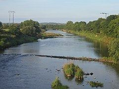
The River Feale (An Fhéil or Abhainn na Féile in Irish) rises near Rockchapel in the Mullaghareirk Mountains of County Cork in the southwest of Ireland and flows northwestwards for 75 kilometres through Abbeyfeale in County Limerick and Listowel in County Kerry before finally emptying into the Mouth of the Shannon by Ballyduff. Then it flows out through the Shannons estuary and joins with the Atlantic Ocean with a flow rate of 34.6 m2/s. The river, along with its tributaries, combine to add to over 160 km (100 miles) of waterways. The river contains a large Salmon and Sea trout population.
Contents
Map of River Feale, Co. Kerry, Ireland
NameEdit
According to Geoffrey Keating's Foras Feasa ar Éirinn (compiled in the 1630s), the river takes its name from a legendary woman:
Fuair Fial bean Lughaidh mic Íotha bás do náire ar bhfaicsin a nochta da céile ar dteacht ó shnámh dhi; gonadh uaithe ghairmthear Innbhear Féile don abhainn sin ó shoin i le
Fial wife of Lughaidh son of Ioth died of shame on her husband seeing her naked as she returned from swimming; and from her that river has ever since been called Innbhear Feile