
Length 24 km | ||
 | ||
River mouth | ||
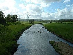
The River Calder is a major tributary of the River Ribble, starting in Cliviger close to Burnley in Lancashire, England and is around 15 miles / 24 km in length. Its source is very close to that of the West Yorkshire river with the same name, and that of the River Irwell. It flows through Towneley Park passing Unity College and Fulledge Recreation Ground. It passes through a culvert in the Burnley Embankment on the Leeds and Liverpool Canal and on through Burnley town centre where it is joined by the River Brun at Active Way. It then flows north through the site of Burnley College and out of the town, where it is joined by Pendle Water before turning west past Ightenhill and Gawthorpe Hall and through the town of Padiham. It flows through Altham and Whalley, passing the ruins of Whalley Abbey, then being crossed by the red brick Whalley Viaduct. It meets the Ribble near Great Mitton.
Contents
In its passage east of Padiham the river was diverted in the 19th century away from Gawthorpe Hall because of pollution, being restored to the original route in the 1960s.