
Founded by provincial law 3273 Demonym(s) rivadaviense Area 3,940 km² Capital América | Established September 30, 1910 Seat América Postal Code B6237 Area code 2337 | |
 | ||
Rivadavia is a partido in the northwest of Buenos Aires Province, Argentina, on the border with La Pampa Province. It has an area of 3,940 square kilometres, and a population of 15,452 (2001 census ).
Contents
Map of Rivadavia Department, Buenos Aires Province, Argentina
The partido, created in 1910, has the town of América as its capital, and its main economic activities are cattle, and the cultivation of wheat, maize and soya beans. Most of the Soya grown in rivadavia partido is of the genetically modified variety.
Name
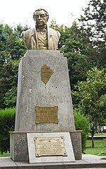
The Partido is named in honour of Bernardino Rivadavia (1780–1845), veteran of the Argentine War of Independence and President of Argentina 1826–1827.
Districts (localidades)
References
Rivadavia Partido Wikipedia(Text) CC BY-SA