
 | ||
Similar Childe's Tomb, Hound Tor, Bowerman's Nose, Great Links Tor, Dartmoor crosses | ||
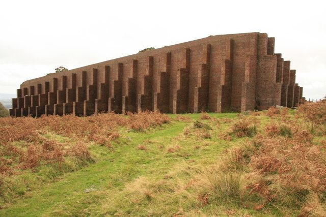
Ww2 rippon tor rifle range from the shooting mounds
Rippon Tor Rifle Range is a disused rifle range within Dartmoor National Park, Devon, England. The range is situated southeast of the 473 m high Rippon Tor, near the village Widecombe-in-the-Moor, and close to the road between Halshanger and Cold East Cross.
Contents
Ww2 rippon tor rifle range footage made with parrot bebop
History
Upon the outbreak of the Second World War, most of the Moor saw renewed activity, as it was commandeered for the use of military training. Various training was undertaken, including artillery firing. A large area of 4,451 hectares to the south and south east of Hexworthy was taken over for rifle, machine gun and anti-tank firing. A new rifle range was built near Rippon Tor to train soldiers, an airfield was constructed on Roborough Down, and a new hutted camp was built at Plasterdown. The latter was later used as a hospital by the American Forces. The newtake below Rippon Tor was chosen as the site for the firing range, and it was successfully built in 1941. Following the end of the war, training cadets became the main users of the range.
Whenever training took place, red warning flags were hoisted on poles at Cold East Cross, Hemsworthy Gate, Rippon Tor and elsewhere around the site. 800 square metres of the surrounding moor would be closed to public access.
Bob Butler and Phill Germon, from Ashburton, were the original range wardens.
Although most main firing ranges in Dartmoor were closed by the late 1940s/early 1950s, Rippon Tor Rifle Range continued to be active until the mid-1960s. The range closed in 1977 on the expiry of its lease, although the closure was also pushed by the Dartmoor National Park Committee, who objected to its use due to dangers to the public walking on the moors. Afterwards further opposition continued from some who wanted the butt destroyed, however the landowner had decided that it should remain as a piece of wartime archaeology.
Design
The majority of the site remains in good condition. The main part of the site features the monumental brick stop butt, estimated to be 55 metres long by 15.5 metres wide and around 9.2 metres high. This structure is supported by nineteen buttresses on the north side and six buttresses on both the east and west sides. The back stop is infilled with earth, gravel and sand to form a sloping bank facing South. This was the receiving end, where shots were fired into the bank. On the opposite side of the butt is the markers' gallery, which still holds the rusting machinery that once operated the raising and lowering of the targets, as well as remains of seat supports. The gallery consists of twelve target frames, (using the Hythe pattern), and associated winding mechanisms, housed in a concrete, earth-covered bunker. This section was built of cantilevered concrete sections on a brick wall, and allowed the range operators to raise and lower targets, patch shot holes and signal adjustments to firing points, where necessary. A now-roofless building is located at the eastern side of the gallery which once served as the target store and workshop.
The soldiers would fire at the stop butt from four large earth mounds spaced out across the hillside to the east. These mounds are approximately 91.5 metres apart. These mounds remain, as do some dug-in concreted pits on the top of these banks.
Inside the entrance gate of the site, to the south-west of the main site, there are two other ancillary buildings. A troop shelter remains with wooden benches where soldiers sat to wait their turn for practice. This consists of a long building comprising twenty-four bays and is constructed of concrete block with an asbestos roof. Each bay of the building is defined by a reinforced concrete framework over which lie wooden battens that support the roof, whilst the rear wall has a number of buttresses. Brick plinths remain, and these are likely to have supported benches. The shelter has been incorrectly identified as stables. A now-roofless, small room at one end of the structure remains, with a tree growing inside it. Near to this building are the remains of a toilet block with seven cubicles. A possible vehicle park is located close by, adjacent to the highway and to the track that leads to the butts.
A possible pumping station for the range, next to the road between Cold East Cross and Halshanger Cross, was noted in a survey of the site in 2010. The remains of a water storage structure, located close to the butts, measuring 5.7 by 3.8 metres, encloses four galvanised storage tanks.