
Area 226 acres (91 ha) Year built 1628 Added to NRHP 2 November 1978 | ||
 | ||
Area 195 acres (79 ha) (listed area) | ||
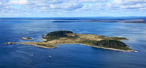
Richmond Island, or Richmond's Island, is an island off the coast of Cape Elizabeth in Cumberland County, Maine, in the United States. The island's name honors Ludovic Stewart, 2nd Duke of Lennox and 1st Duke of Richmond. Privately owned and unoccupied, it is notable as the site of a permanent fishing post in the 17th century, and was listed on the National Register of Historic Places in 1978 for the significance of that post's archaeological remains.
Contents
Map of Richmond Island, Cape Elizabeth, ME 04107, USA
Geography
Richmond Island is located off the southern coast of Cape Elizabeth, near the northeastern end of Saco Bay in the Gulf of Maine. The island is 226 acres (91 ha) in size. The island has no permanent occupants, and the only structures on it are a lodge, keeper's quarters, and boat dock, located on its northwestern shore. The island is privately owned by the Sprague Corporation, through which permission to camp on the island can be arranged.
History
The island's first known settler was Walter Bagnall, who operated a fishing station from 1627 to 1631, the year of his death at the hands of local Native Americans. In 1631 Robert Trelawney, an English merchant, was granted a patent for land in the area, and he sent John Winter to establish a permanent fishing station on the island. From 1633 to 1643 Winter, with a crew of about 40 men, operated the station, building a substantial house, and engaging in agriculture on the land. The station was fortified against the threats of attack from Native Americans, and the Acadian settlement at Fort Pentagoet in Penobscot Bay.