
Elevation 1,445 m Parent range Blue Ridge Mountains | ||
 | ||
Similar Snake Mountain, Richland Balsam, Howard Knob, Grassy Mountain, Looking Glass Rock | ||
Rich Mountain is a mountain located in the North Carolina High Country, northwest of the town of Boone. Its elevation reaches 4,741 feet (1,445 m).
Contents
Map of Rich Mountain, Brushy Fork, NC 28607, USA
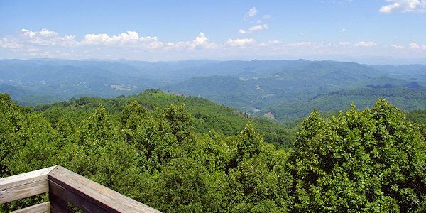
The mountain is sometimes confused with Howard Knob, which is to its immediate east; sharing the same ridge to the west is Snakeden Mountain. Its summit can be reached by taking Fire Tower Road; depending on vegetation, visitors can get clear views of Boone and the surrounding areas.
The mountain generates several feeder streams to the South Fork New River (via Doe Fork) and the Watauga River (via Laurel Fork).
Rich Mountain #2
A second Rich Mountain is also located south of Boone, near Moses H. Cone Memorial Park. Its elevation reaches 4,199 feet (1,280 m). Because it's within' both the Pisgah National Forest and Blue Ridge Parkway it is protected from development. From 1922-1985, Camp Yonahlossee (Cherokee for "Trail of the Bear") was located at the western side of the mountain, it was one of the oldest all girls camp in North Carolina; today it is a resort and club.
The mountain generates several feeder streams to the South Fork New River (via Winkler Creek) and the Watauga River (via Cannon Branch).