
Highest elevation 3630 Status Retreating | Lowest elevation 2200 | |
 | ||
Similar Furka Pass, Alps, Grimsel Pass, Aletsch Glacier, Furka Base Tunnel | ||
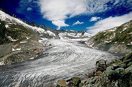
The Rhône Glacier (German: Rhonegletscher, Walliser German: Rottengletscher, French: le glacier du Rhône) is a glacier in the Swiss Alps and the source of the river Rhône and one of the primary contributors to Lake Geneva in the far eastern end of the Swiss canton of Valais. Because the Glacier is located close to the Furka Pass road it is easily accessible.
Contents
Map of Rh%C3%B4ne Glacier, 3999 Obergoms, Switzerland
Geography
The Rhône Glacier is the largest glacier in the Urner Alps. It lies on the south side of the range at the source of the Rhône. The Undri Triftlimi (3,081 m) connects it to the Trift Glacier. The glacier is located on the northernmost part of the canton of Valais, between the Grimsel Pass and the Furka Pass and is part of the Oberwald municipality. The Dammastock (3,630 m) is the highest summit above the glacier. During most of the past 11,000 years it was smaller than it is now. It is covered each summer in white blankets to try and slow ice loss.
The Rhône Glacier is easily accessible so its evolution is observed since the 19th century. The glacier lost ~1300 m during the last 120 years leaving behind a track of naked stone.