
Type Highway Route number(s) State Route 3 | Opened 1980s Length 26 km | |
 | ||
Major cities | ||
Reid highway bridge over mitchell freeway
Reid Highway is a 23 kilometre east-west highway and partial freeway in the northern suburbs of Perth, Western Australia, linking North Beach with Middle Swan. As part of State Route 3, it forms half of Perth's outer ring road along with Roe Highway, which it joins onto at its eastern terminus.
Contents
- Reid highway bridge over mitchell freeway
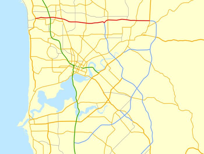
- Map of Reid Hwy Western Australia Australia
- Reid highway beam lift over mitchell freeway long video
- History
- Future works
- Route description
- Interchanges and intersections
- References
Map of Reid Hwy, Western Australia, Australia
The highway has many variable speed limits and road conditions along its length, but is predominantly a four-lane dual carriageway with a 90 km/h speed limit. An 8 kilometre section, between Erindale Road and Tonkin Highway, is a continuous freeway. In conjunction with Tonkin Highway, it serves as an important arterial connection between Perth's coastal and eastern suburbs, industrial areas and Perth Airport.
Reid highway beam lift over mitchell freeway long video
History
Reid Highway was initially proposed in the late 1960s as the "North Perimeter Highway", and a small two-lane section was built in early 1986 between Erindale Road and the-then newly extended Mitchell Freeway. In 1989 it was subsequently renamed "Reid Highway", in honour of former Western Australia Governor Gordon Reid.
The next section was built between Alexander Drive and Malaga Drive, and was opened on 6 September 1991. A segment linking Malaga Drive to Tonkin Highway opened later that year, on 11 November 1991, with further extensions west to Mirrabooka Avenue and east to Beechboro Road opening two months later, on 11 February 1992.
The highway was further extended with the section between Mirrabooka Avenue and Wanneroo Road, which opened on 17 November 1994. The highway was finally made continuous on 6 September 1996 with the opening of the Erindale Road–Wanneroo Road segment. A short time later, it was extended eastwards to West Swan Road. This section, which opened on 25 November 1996, provided a connection to Great Northern Highway and Roe Highway via Middle Swan Road, an existing local road.
In 2001, the highway was extended west from Mitchell Freeway to Marmion Avenue as a two-lane divided carriageway, which opened on 30 July. This extension was highly controversial as it passes through the environmentally sensitive Carine wetlands and the Lake Carine region, which includes a vital turtle habitat. Concerns about environmental damage prompted construction delays, and slight alterations to the route.
Criticism of the quality and capacity of the highway has also been an issue. Reid Highway in Westminster (between Wanneroo Road and Mirrabooka Avenue) has no street lighting and has attracted both antisocial behaviour and a number of accidents. The stretch between Beechboro Road and West Swan Road has been similarly criticised, and the area east of the Mitchell Freeway was prone to heavy congestion due to its limited capacity as a two-lane single carriageway, before being upgraded to dual carriageway.
A four-lane dual carriageway extension of Reid Highway from West Swan Road to Great Northern Highway and Roe Highway was opened on 26 February 2010, completing State Route 3 as a highway-grade ring road around Perth. The extension runs parallel to Middle Swan Road, which has been retained as a local access road. Middle Swan Road is of a relatively poor standard and capacity, and is viewed as a safety blackspot.
In 2011, the highway's traffic-light intersections at Alexander Drive and Mirrabooka Avenue were both upgraded to diamond interchanges, with bridges being constructed to carry highway traffic. Along with the similarly grade-separated Wanneroo Road interchange, this completed an 8 kilometre section of grade-separated, free traffic flow between the industrial estates of Balcatta and Malaga.
The T junction at Lord Street has been upgraded to a traffic light controlled intersection, with four through lanes and improved turning lanes on Reid Highway.
The RAC has lobbied for continued improvements to Reid Highway, calling for grade-separation at the Malaga Drive intersection, and to make the highway a dual carriageway for its entire length. The WA State Government initially did not commit to further major upgrades, instead funding an upgrade to the turning lanes at the Malaga Drive intersection. In December 2012, the State Government announced that the Malaga Drive intersection would be grade separated by 2014-15, with work commencing in 2013-14. The project uses the same diamond interchange design that was constructed at Alexander Drive and Mirrabooka Avenue in 2011.
Works were completed in 2016 to upgrade the Mitchell Freeway diamond interchange to dual carriageway with a second overpass bridge, extra turning lanes, and a new looped freeway ramp. The project aims to lower congestion, and reduce the volume of traffic using local roads to avoid the interchange. The works also included upgrading the Duffy Road intersection to traffic light control, and widening of the highway to the west of Duffy Road.
Future works
The intersection with Tonkin Highway will be upgraded as part of the Northlink WA project to a cloverstack interchange, with the new Perth Darwin National Highway being built heading north from the interchange. Construction will start early 2017 and will be finished by mid 2019. As part of these works, access to Beechboro Road North will be removed, and a flyover built.
Route description
Reid Highway runs between Marmion Avenue, North Beach, and Great Northern Highway, Middle Swan, where it becomes Roe Highway. West of Marmion Avenue, the highway becomes North Beach Road (West).
Most junctions on the highway are at-grade, with all crossroad intersections traffic light controlled and most T junctions not controlled by traffic lights. The exceptions are Wanneroo Road, Mirrabooka Avenue, Alexander Drive, and Malaga Drive, which are grade-separated diamond interchanges, and Okley Road, Duffy Road South, and Tonkin Highway, which are traffic light controlled T junctions. The intersection with Tonkin Highway is unusual in that Tonkin Highway, which continues as Reid Highway west of the intersection, is the continuous section of the T junction. To continue travelling on Reid Highway, one must turn left (eastbound) or right (westbound) at the intersection. Middle Swan Road and Harris Road are left-in/left-out T junctions that connect via an underpass. They are signposted as being "temporary access". Alternative access will be required in the future, as Reid Highway is planned to be upgraded to a six lane freeway.
Interchanges and intersections
The entire highway is located in the Perth Metropolitan Region.