
Admin. region Köln Elevation 289 - 342 m (−833 ft) Local time Monday 7:54 AM | Time zone CET/CEST (UTC+1/+2) Population 19,526 (31 Dec 2010) | |
 | ||
Weather 1°C, Wind E at 11 km/h, 76% Humidity Points of interest Monkey & bird park Eckenhagen, Rodelpiste Eckenhagen, Ski und Rodelanlage | ||
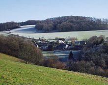
Reichshof is a North Rhine-Westphalian municipality in the Oberbergischer Kreis in Germany, about 40 km east of Cologne. It is a health resort, known for its good climate.
Contents
- Map of 51580 Reichshof Germany
- General meaning
- The coat of arms of Reichshof
- Economy
- Schools and educational facilities
- Places of interest
- Sports sites
- Sons and daughters of the municipality
- Twin towns
- References
Map of 51580 Reichshof, Germany
General meaning
As a sequence of the municipal re-organization 1969 the municipalities independent up to now Denklingen and to Eckenhagen were summarized to the municipality Reichshof. The management seat of the municipality Reichshof is in Denklingen.
A base Charlemagne was also designated imperial court. This dragged from imperial court to imperial court to be able to administer his empire.
The coat of arms of Reichshof
The arms were granted on September 11, 1972.
The name is taken from the former Imperial Estate Reichshof Eckenhagen, which was established in 1167 and acquired by the Counts of Berg in 1257. The upper part of the arms shows the Imperial Eagle, and is used as a canting symbol for the municipality. The lower part is the lion of the Counts of Berg, and is taken from the seal of Eckenhagen from 1557.
Economy
In the new industria area of Wehnrat (Available surface, 50,000 square meters.) some significant companies are settled meanwhile, e.g.
A large employer in the municipality Reichshof is BPW Bergische axle Wiehl, with its branch factories in Brüchermühle and in Hunsheim.