
Type Public park Status Open year round Founded 1814 | Location London, England Area 166 ha Phone +44 300 061 2300 | |
 | ||
Website www.royalparks.org.uk/parks/the-regents-park Address Chester Rd, London NW1 4NR, UK Profiles | ||
Regent s park london full hd video canon hf s200
Regent's Park (officially The Regent's Park) is one of the Royal Parks of London. It lies within north-west London, partly in the City of Westminster and partly in the London Borough of Camden. The population of the Camden ward at the 2011 Census was 13,528. It contains Regent's University London and the London Zoo.
Contents
- Regent s park london full hd video canon hf s200
- London s regent s park
- Description
- Management
- History
- Sport
- The terraces
- The villas
- More attractions
- Nearest Tube stations
- Nearest railway stations
- References
The park is Grade I listed on the Register of Historic Parks and Gardens.
London s regent s park
Description
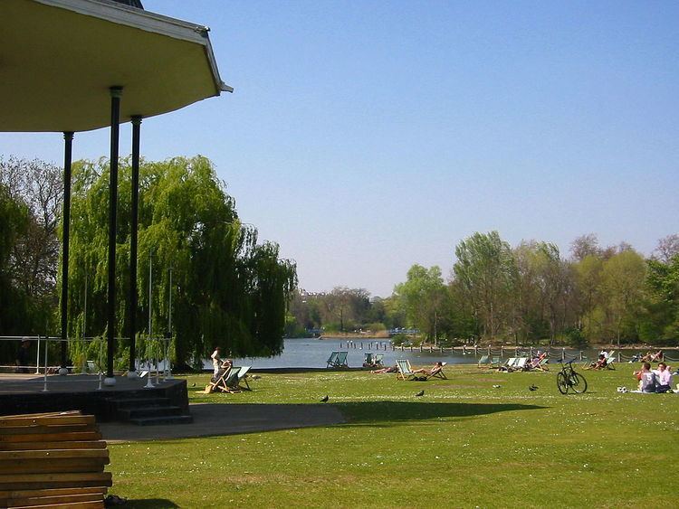
The park has an outer ring road called the Outer Circle (4.45 km) and an inner ring road called the Inner Circle (1 km), which surrounds the most carefully tended section of the park, Queen Mary's Gardens. Apart from two link roads between these two, the park is reserved for pedestrians. The south, east and most of the west side of the park are lined with elegant white stucco terraces of houses designed by John Nash and Decimus Burton. Running through the northern end of the park is Regent's Canal, which connects the Grand Union Canal to the former London docks.
The 166 hectares (410 acres) park is mainly open parkland with a wide range of facilities and amenities, including gardens; a lake with a heronry, waterfowl and a boating area; sports pitches; and children's playgrounds. The northern side of the park is the home of London Zoo and the headquarters of the Zoological Society of London. There are several public gardens with flowers and specimen plants, including Queen Mary's Gardens in the Inner Circle, in which the Open Air Theatre is located; the formal Italian Gardens and adjacent informal English Gardens in the south-east corner of the park; and the gardens of St John's Lodge. Winfield House, the official residence of the U.S. Ambassador to the United Kingdom, stands in private grounds in the western section of the park. Nearby is the domed London Central Mosque, better known as Regent's Park mosque, a highly visible landmark.
Located to the south of the Inner Circle is Regent's University London, home of the European Business School London, Regent's American College London (RACL) and Webster Graduate School among others.
On the northern side of Regent's Park is Primrose Hill, another open space, which with a height of 256 feet (78 m) has a clear view of central London to the south-east, as well as Belsize Park and Hampstead to the north. Primrose Hill is also the name given to the immediately surrounding district.
Management
The public areas of Regent's Park are managed by The Royal Parks, a government agency. The Crown Estate Paving Commission is responsible for managing certain aspects of the built environment of Regent's Park. The park lies within the boundaries of the City of Westminster and the London Borough of Camden, but those authorities have only peripheral input to the management of the park. The Crown Estate owns the freehold of Regent's Park.
History
In the Middle Ages the land was part of the manor of Tyburn, the property of Barking Abbey. In the Dissolution of the Monasteries, Henry VIII appropriated the land, and it has been Crown property ever since, except for the period between 1649 and 1660. It was set aside as a hunting park, known as Marylebone Park, until 1649. It was then let out in small holdings for hay and dairy produce.
When the leases expired in 1811 the Prince Regent (later King George IV) commissioned architect John Nash to create a masterplan for the area. Nash originally envisaged a palace for the Prince and a number of grand detached villas for his friends, but when this was put into action from 1818 onwards, the palace and most of the villas were dropped. However, most of the proposed terraces of houses around the fringes of the park were built. Nash did not complete all the detailed designs himself; in some instances, completion was left in the hands of other architects such as the young Decimus Burton. The Regent Park scheme was integrated with other schemes built for the Prince Regent by Nash, including Regent Street and Carlton House Terrace in a grand sweep of town planning stretching from St. James's Park to Parliament Hill. The scheme is considered one of the first examples of a garden suburb, and continues to influence the design of suburbs. The park was first opened to the general public in 1835, initially for two days a week. The 1831 diary of William Copeland Astbury describes in detail his daily walks in and around the park, with references to the Zoo, the canal, and surrounding streets, as well as features of daily life in the area.
On 15 January 1867, forty people died when the ice cover on the boating lake collapsed and over 200 people plunged into the lake. The lake was subsequently drained and its depth reduced to four feet before being reopened to the public.
Late in 1916 the Home Postal Depot, Royal Engineers moved to a purpose built wooden building (200,000 sq ft) on Chester Road, Regent’s Park. This new facility contained the Home Postal Depot administration offices, a large parcel office and army letter office both of which moved from GPO Mount Pleasant. HM King George V and HM Queen Mary visited Home Postal Depot at Regent’s Park on 11 December 1916. The Depot vacated the premises in early 1920.
Queen Mary's Gardens in the Inner Circle were created in the 1930s, bringing that part of the park into use by the general public for the first time. The site had originally been used as a plant nursery and had later been leased to the Royal Botanic Society.
In 1982 an IRA bomb was detonated at the bandstand, killing seven soldiers.
The sports pitches, which had been relaid with inadequate drainage after the Second World War, were relaid between 2002 and 2004, and in 2005 a new sports pavilion was constructed.
On 7 July 2006 the Park held an event for people to remember the events of the 7 July 2005 London bombings. Members of the public placed mosaic tiles on to seven purple petals. Later bereaved family members laid yellow tiles in the centre to finish the mosaic.
Sport
Sports are played in the park including Tennis, Netball, Athletics, Cricket, Softball, Rounders, Football, Hockey, Australian Rules Football, Rugby, Ultimate Frisbee and Running. Belsize Park Rugby Football Club play their home games in the park.
There are three playgrounds and there is boating on the lake.
Sports take place in an area called the Northern Parkland, and are centred on the Hub. This pavilion and underground changing rooms was designed by David Morley Architects and Price & Myers engineers, and opened by Queen Elizabeth II in 2005. It won the IStructE Award for Community or Residential Structures in 2006.
The Outer Circle is used by road cyclists - one circuit is 4.5 km.
The park was scheduled to play a role in the 2012 Summer Olympics, hosting the baseball and softball, but these sports were dropped from the Olympic programme with effect from 2012. The Olympic cycling road race was supposed to go through Regent's Park, as was the cycling road race in the 2012 Summer Paralympics, but the routes were changed. The Park also plays host to London Camanachd who have regular shinty scrimmages there.
The terraces
John Nash was appointed architectural 'overseer' for the Regent's Park projects of Decimus Burton: Cornwall Terrace, York Terrace, Chester Terrace and the villas of the Inner Circle, including The Holme. However, to the chagrin of Nash, Decimus largely disregarded his advice and developed the Terraces according his own style, to the extent that Nash sought the demolition and complete rebuilding of Chester Terrace, but in vain. Decimus's terraces were built by his father, James Burton (property developer).
Clockwise from the north the terraces are:
Immediately south of the park are Park Square and Park Crescent, also designed by Nash.
The villas
Nine villas were built in the park. There follows a list of their names as shown on Christopher and John Greenwood's map of London (second edition, 1830), with details of their subsequent fates:
Close to the western and northern edges of the park
Around the Inner Circle
Close to the eastern edge of the park