
Time zone CET/CEST (UTC+1/+2) Area 109.7 km² Postal code 46459 Administrative region Düsseldorf | Postal codes 46459 Population 22,267 (31 Dec 2010) Local time Sunday 8:53 PM | |
 | ||
Weather 10°C, Wind NE at 10 km/h, 57% Humidity | ||
Rees is a town in the district of Cleves in the state of North Rhine-Westphalia, Germany. It is located on the right bank of the Rhine, approx. 20 km east of Cleves. Population (2005): 22,559. Founded in 1228, Rees is the oldest town in the lower Rhine area.
Contents
- Map of 46459 Rees Germany
- Organization and neighbouring municipalities
- History
- Mayor
- Culture Tourism and Points of Interest
- Railway
- Major roads
- Inland waterways
- Nearest airports
- Personalities
- References
Map of 46459 Rees, Germany
Organization and neighbouring municipalities
Rees is administratively organized in eight communities:
The neighbouring municipalities are Oude IJsselstreek (province of Gelderland, NL) and Isselburg (district of Borken) in the North, Hamminkeln and Wesel in the East, Xanten in the South (all district of Wesel), and Kalkar and Emmerich in the West.
History
The origin of the town is a Frankish settlement established between 500-800 AD. The name Rees most probably goes back to the Franconian term "Rys", which means "willow grove".
The Lower Rhine area was Christianized by the Irish missionary Willibrord between 657-739. Around 1000 the nearby monastery of Aspel was first mentioned.
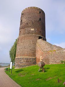
On 14 July 1228 Rees was granted municipal rights by Heinrich I von Müllenark, Archbishop of Cologne. At that time it had about 600 inhabitants. In 1289/90 the works on a fortified city wall began, which was completed in 1350. In 1392 Rees and the monastery of Aspel became parts of the County of Cleves.
During the Eighty Years War, the town was captured by Spanish troops in 1598. After the death of the last duke of Cleves in 1609 the town belonged to the Margraviate of Brandenburg. Between 1616 and 1625 Rees was occupied by Dutch troops who transformed the town into a huge fortress. In 1701 Rees became a part of the Kingdom of Prussia.
In 1816 Rees became capital of the newly founded Rees District within Regierungsbezirk Kleve. The railway line from Oberhausento Arnhem was inaugurated in 1856 and a railway station was built near Rees. At the beginning of the 20th century Rees had 4.096 inhabitants of whom 330 were Protestants and 52 were Jews.
During the Nazi period, many Jewish inhabitants were deported. Today the only reminders on Jewish culture in Rees are two historic Jewish cemeteries. The city was almost completely destroyed by an Allied air raid on February 16, 1945 during World War II. It became part of North Rhine-Westphalia after the war.
The Rhine bridge of Rees was completed in 1967.
Mayor
The mayor of Rees is since 2009 Christoph Gerwers (CDU). He was reelected in 2015 with 66,6 % of the votes.
Culture, Tourism and Points of Interest
Railway
The train station Empel-Rees, located about 4 km from the city center, is connected northbound to Emmerich and southbound to Wesel-Oberhausen-Duisburg-Düsseldorf-Cologne-Bonn-Koblenz. From the station, there is a bus line downtown. There stations in Millingen and Haldern as well.
Major roads
Rees has major road access to the Autobahn A3 and the federal roads B8 (North-South) and B67 (East-West).
Inland waterways
For pedestrians and bicyclists, transfer across the Rhine is provided by two ferries from Easter holidays through October.
Nearest airports
Distance to Düsseldorf Airport: ca. 75 km
Distance to Airport Weeze (low cost carriers only): ca. 35 km