
- elevation 1,532 ft (467 m) Length 117 km Basin area 575 km² | - elevation 1,263 ft (385 m) Basin area 575 km² | |
 | ||
Mouths Leaf River, Bullard Township | ||
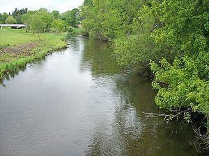
The Redeye River is a tributary of the Leaf River, 73 miles (117 km) long, in central Minnesota in the United States. Via the Leaf and Crow Wing Rivers, it is part of the watershed of the Mississippi River, draining an area of 222 square miles (575 km²) in a rural region. The river's name comes from the Native Americans of the area, who saw many red-eye fish in the river.
Contents
Map of Redeye River, Minnesota, USA
Geography
The Redeye River rises in a morainic region, issuing from Wolf Lake in Toad Lake Township in southeastern Becker County. It flows generally southeastwardly through northeastern Otter Tail and central Wadena Counties, through the city of Sebeka, and enters the Leaf River in Bullard Township in southeastern Wadena County, eight miles (13 km) upstream of the Leaf River's mouth at the Crow Wing River. The river's course is within the North Central Hardwood Forest ecoregion, which is characterized by hardwood forests of maple and basswood mixed with conifers, on outwash plains and moraines amid flat glacial lakes.