
Website www.reda.pl Population 22,000 (2011) Local time Sunday 2:56 PM | Postal code 84-240 Area 29.45 km² | |
 | ||
Weather 12°C, Wind W at 14 km/h, 39% Humidity | ||
Aquapark reda poland 23 02 2017
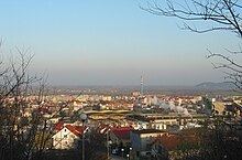
Reda [ˈrɛda] Pomeranian: Réda, German: Rheda) is a town on the river Reda in Kashubia or Eastern Pomerania region, north-western Poland with some 17,000 inhabitants. Situated in the Wejherowo County in Pomeranian Voivodeship since 1999, previously in Gdańsk Voivodeship (1975-1998).
Contents
Map of Reda, Poland
It is connected by well developed railway and highway connections to the Tricity, an aglomeration of over 1 million on the coast of Gdańsk Bay.
Village Reda
Village Reda
In 1357 first mentioned in documents. Later it shared the history of the province:
annexed by Germany to the province Danzig-West Prussia
References
Reda, Poland Wikipedia(Text) CC BY-SA