
Time zone WET (UTC+0) Elevation 68 m Local time Saturday 2:53 AM | Irish Grid Reference W804920 Population 1,534 (2011) | |
 | ||
Weather 4°C, Wind N at 10 km/h, 86% Humidity | ||
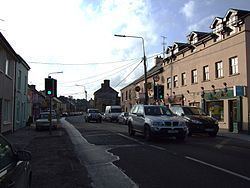
Rathcormac (Irish: Ráth Chormaic, meaning "Cormac's ringfort") is a small town in north County Cork, Ireland. Previously situated on the main Cork to Dublin road (the N8), it was bypassed in 2006 by the M8. The former N8 through Main St is now the R639 regional road.
Contents
Map of Rathcormac, Co. Cork, Ireland
History
The Rathcormac massacre occurred at Bartlemy Cross southeast of Rathcormac on 18 December 1834, during the Tithe War.
Carntierna, an Iron Age royal site, is located to the north.
SportFile
Rathcormac is home to Bride Rovers GAA club. and Rathcormac Gun Club
Amenities
The Rathcormac Inn Bar and Restaurant, Barrys Bar, Benskin's Bar and O'Coilleans Bar. There is also a tennis court, children's playground, Big Vinnies Chipper, Fitzy's Chipper, Phoenix House Chinese, A beauticians, a petrol station and a Community Hall.
Agriculture
Located in the Blackwater Valley region, Rathcormac has good agriculture due to vast fields and good soil conditions. Sunnyside Fruit Farm is located just outside Rathcormac
People
Rathcormac is the home village of 2011 Irish General Election Candidate Pa O'Driscoll. In 1842 the Fenian and Australian architect, Joseph Nunan, was born here.