
Length 13 km | ||
 | ||
Sources North Branch Rancocas Creek, South Branch Rancocas Creek Similar Rancocas State Park, Riverside–Delanco Bridge, Historic Smithville Park, Amico Island Park, Rancocas Nature Center | ||
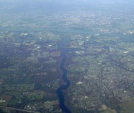
Rancocas Creek is a tributary of the Delaware River in southwestern New Jersey in the United States. The creek's main stem is 8.3 miles (13.4 km) long, with a North Branch of 28.3 miles (45.5 km) and a South Branch flowing 21.7 miles (34.9 km). The creek system drains a rural agricultural and forested area on the western edge of the Pinelands north and northeast of Camden and the New Jersey suburbs of Philadelphia.
Contents
Map of Rancocas Creek, New Jersey, USA
OverviewEdit
Rancocas Creek rises as two main branches in the Pinelands National Reserve. The North Branch rises in northern Burlington County, in Mirror Lake, just south of Fort Dix. It flows west-northwest past Mount Holly.
The South Branch rises in central Burlington County near Chatsworth and flows generally northwest. It receives the 13.8-mile-long (22.2 km) Southwest Branch from the south approximately 5 miles (8 km) south of Mount Holly. The North and South branches join near Rancocas State Park, approximately 3 miles (5 km) west of Mount Holly, near the crossing of the New Jersey Turnpike and Interstate 295. A few hundred yards downstream of the Interstate 295 and NJ Turnpike bridges, Burlington County Route 635 passes over the Creek on a bridge built less than 4 feet (1.2 m) over the average water level. This bridge has the capability for the center section of the bridge to swivel from the perpendicular to the river to parallel, to allow small boat traffic through. After rehabilitation of the bridge in the 1980s, the powered mechanism was removed due to the near-lack of creek barge traffic and expense of maintenance. The bridge may be opened in case of emergency, but requires manual labor to be swiveled open.
It is navigable for approximately 10 miles (16 km) upstream from its mouth on the Delaware. However, the CR 635 bridge effectively places a barrier to boat traffic 7.6 miles (12.2 km) upstream from the Delaware.
TributariesEdit
AccidentsEdit
On April 23, 1853, the engineer of Camden & Amboy's 2 p.m. train out of Philadelphia missed stop signals and ran his train off an open drawspan between modern-day Riverside and Delanco on Rancocas Creek. Fortunately, there were no fatalities.