
Elevation 2,092 m Prominence 647 m Mountain range Elk River Mountains | Topo map NTS 92F/12 First ascent 1964 | |
 | ||
Similar Mount Colonel Foster, Elkhorn Mountain, Kings Peak, Mount McBride, Golden Hinde | ||
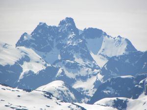
Rambler Peak is a mountain located on Vancouver Island, British Columbia. The mountain is 23 km (14 mi) east of Gold River and 4 km (2 mi) southeast of Mount Colonel Foster
Contents
Map of Rambler Peak, Comox-Strathcona D, BC, Canada
This mountain is a hydrographic divide located at the headwaters of the Elk River. The Wolf, Elk, Ucoma Rivers and Cervus Creek all start at Rambler Peak.
History
The difficulty in scaling this peak defeated attempts for many years. The first successful attempt was July 19, 1964 when Cameron Powell, Barrie McDowell and Steve Todd of the Island Ramblers Mountaineering Club reached the top. The mountain was named in honour of their club. Rambler peak was originally called El Piveto Mountain a name by which another BC mountain is now known.
References
Rambler Peak Wikipedia(Text) CC BY-SA