
Population 1,928 (2011) Sovereign state United Kingdom Local time Thursday 10:48 AM | OS grid reference SO413077 Country Wales Postcode district NP15 Dialling code 01291 | |
 | ||
Weather 7°C, Wind NE at 26 km/h, 87% Humidity | ||
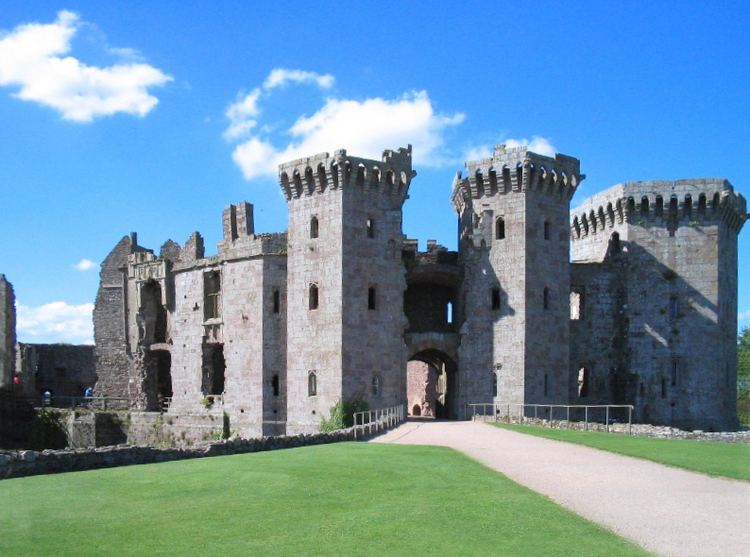
Raglan (Welsh: Rhaglan) is a village in Monmouthshire, south east Wales, United Kingdom. It is located some 9 miles south-west of Monmouth, midway between Monmouth and Abergavenny on the A40 road very near to the junction with the A449 road. The fame of the village derives from its large castle, Raglan Castle, built for William ap Thomas, and now a magnificent 15th-century ruin maintained by Cadw.
Contents
Map of Raglan, Usk, UK
History
The origins of the village are unknown but Raglan was first mentioned in the will of Walter de Clare
The earliest market in Raglan was recorded in 1354. The market cross in the town, which stands in the centre of the cross roads between the church and the Beaufort Arms Inn, consists now only of a massive base on which has been mounted a lamp post. In the large space around this stone the markets were held, the base of the cross doubtless forming the table on which bargains were struck.
The agricultural roots of Raglan are illustrated by a 1397 account between the ‘reevem’ or reeve Ieuan Hire and Ieuan ap Grono and haywards (hedge wardens) Iorwerth ap Gwillym and Hoe ap Gwillym Goch.
St Cadoc's is a substantial mediaeval church, extensively restored in the 19th century by Thomas Henry Wyatt. It houses some much-defaced tombs of the Lords of Raglan. The base of a fine pilgrim's cross can be seen in the churchyard. The first part of the church was built during the 14th century.
The earliest records of the manor of Raglan Court are found in 26 October – 28 July 1391 during the reign of Richard II. At this time Raglan Castle was probably no more than a hill fort. After 1415 Raglan Castle was expanded from a small fort to the substantial castle that we see today.
It wasn’t until 1587 that Raglan was referred to as a town. For the court, 13 July 1587, the marginal heading reads Burgus de Ragland cum Curia Manerii de Ragland cum membris and the caption becomes 'The Court of William Somerset, 3rd Earl of Worcester of his said borough and the Court of the said Earl of his said manor with members'. From 1 June 1587 onwards most courts refer to the Borough of Ragland in the following manner: 'The Court of the said manor with the Court of the borough or the town of Ragland'.
By 1632, a Court House was established in Raglan. "The jury to meet at the Court House at Ragland the 25th March next by ten of the clock under peyn of xls. apeece to have a view and inquire of lands in Landenny (Llandenny) and Ragland late of Philip David Morris", (Dec. 1632).
The English Civil War had disastrous consequences both for Raglan Castle as well as for Raglan village. Raglan Castle was besieged for two months from 3 June to 19 August 1646 by a strong force of Parliamentarians. The Castle finally surrendered to Thomas Morgan, when Sir Thomas Fairfax arrived with 3,500 men and six deadly mortars. ‘The house almost starved … had like to have eaten one another’ was the report and the Parliamentarians called in the local people to help demolish the Marquess's home.
The link between castle and village was severed. The castle ruins became neglected and were used as a quarry for those needing stone to repair their houses: dressed and moulded stones can be seen in farmhouses and cottages in the area.
Subsequent leet courts refer to the liberty of Raglan and in 1682 the hundred of Ragland is mentioned. Court Roll excerpts reflect the growing issues of the day: In 1680, ‘The bridge called Pontleecke upon the highway leading from Raglan towards Chepstow to be out of repair. Moses Morgan fined for not spending 14s of the parish money towards repairing the stocks and whipping post in the parish of Raglan’. In 1695 the repair of bridges are still under discussion, ‘The bridge called Pont y bonehouse in the town of Raglan, 1695. John Curre, gent., steward’.
The castle has dominated the village for the past 350 years and continues to do so, drawing tourists by coach, train and car. Before Cadw took over, the Duke of Beaufort was the hereditary keeper of the castle while generations of Wardens lived either next to the castle or in the village of Raglan. There is no longer a direct train service to the village, the local railway station having closed in 1955, almost a decade before the Beeching Axe. The railway station buildings may still be seen from the A449, however, which passes close by and which runs on the bed of the railway line. (Alas no more, the building has been taken down and some time in the future will be rebuilt at St Fagans.) The village continued to be an important thoroughfare in the 18th and 19th centuries, which explains its three substantial coaching inns, the Beaufort Arms, the Ship and the Crown where the Mail coaches would stop.
Cross at Croes Lwydd Farm
On Broom Lane, to the east of Broom House, stands a medieval stone cross, 1.9 metres (6.2 ft) high, with an octagonal shaft. Bradney describes it as a "singularly well-preserved stone, the head and shaft being hewn out of the same piece." The cross was the subject of Article 452 in the series Monmouthshire Sketchbook by Fred Hando for the South Wales Argus between 1922 and 1970. Hando writes that the cross, one of the only two remaining crosses in Monmouthshire, from a total of 79, which had survived with its head intact following the "Puritan folly of 1643." He describes its name, the "White Cross", as deriving from its whitewashed appearance but says "the appropriate name should be Grey Cross". He suggests that the cross is "at least five centuries" old.
The cross is a Grade I listed structure as of 31 January 2001. It is believed that the cross was removed, in about 1870, from a possible prior location at map reference SO40390659 (N 51.754813, W 2.8649842) The cross is a scheduled ancient monument.