
Population 17,519 Civil parish Quedgeley Dialling code 01452 | OS grid reference SO8047113202 Sovereign state United Kingdom | |
 | ||
Quedgeley is a suburban community 3.5 miles (5.6 km) southwest of the city of Gloucester, England.
Map of Quedgeley, Gloucester, UK
The civil parish of Quedgeley was transferred to Gloucester district in 1991 and is the only civil parish within the city. The 2011 census recorded a population of 17,519 for the parish, which has an area of 576 hectares (1,420 acres). Since the 1980s Quedgeley has become increasingly contiguous with Gloucester and is effectively now the city's largest and outermost southern suburb.
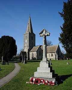
The parish church is St James and is known to have been established before 1137. The octagonal font has panels of gold, coloured tessarae, and blue forest stone. The font is 12th century but was a donation by the then Rev. Winstone Hayward for the re-opening of the church in 1857. While the present-day structure's tower and south aisle are medieval in origin, the remainder of the church is an 1856 restoration by Henry Woodyer in what is considered Victorian Gothic style.
The A38 road runs through Quedgeley, now as a dual carriageway running between Gloucester city centre and the M5 motorway at junction 12; the old route taken by the A38 through Quedgeley is now the B4008. The village of Hardwicke is contiguous to the south of Quedgeley, in the Stroud District.