
 | ||
QuakeSim is a NASA project for modeling earthquake fault systems. It was started in 2001 with NASA funding as a follow up to the General Earthquake Models (GEM) initiative. The multi-scale nature of earthquakes requires integrating data types and models to fully simulate and understand the earthquake process. QuakeSim is a computational framework for modeling and understanding earthquake and tectonic processes.
Contents
- QuakeSim Portal
- QuakeTables
- Developed Software
- QuakeSim related NASA missions
- DESDynI Deformation Ecosystem Structure and Dynamics of Ice
- Affiliates
- References
QuakeSim focuses on modeling interseismic process though various boundary element, finite element, and analytical applications, which run on various platforms, including desktop and high-end computers. The QuakeTables database allows for modelers to access geological and geophysical data. A goal of QuakeSim is to develop significant improvements in earthquake forecast quality, thereby mitigating the danger from this natural hazard.
QuakeSim Portal
The QuakeSim Portal allows for users to access and ingest data into models and simulations. It provides the computational infrastructure for the entire project. QuakeSim users can create an account and interact with different data and software through the portal. The QuakeSim Portal consists of portlets that include:
QuakeTables
QuakeTables is the database used to access information for QuakeSim. Information found in the QuakeTables includes:
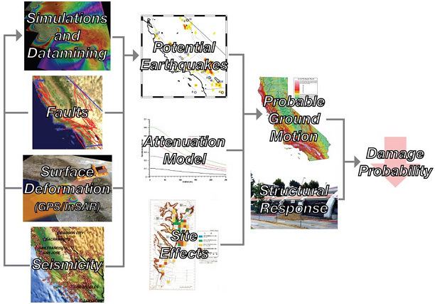
This information plays a big role in the process of forecasting and damage mitigation. The information allows for the creation of simulations and data mining. This then improves the prediction for potential earthquakes. This, along with attenuation modeling and site effects, leads to a better understanding of probable ground motion, allowing for the opportunity to improve structural response.
Developed Software
QuakeSim includes several applications. GeoFEST, PARK, and Virtual California are used to model different aspects of the earthquake cycle. For more information on these programs, and to download them, see the "Download Code" section of the QuakeSim website.
QuakeSim-related NASA missions
QuakeSim utilizes GPS data from NASA, the National Science Foundation, and the US Geological Survey Southern California Integrated GPS Network (SCIGN). QuakeSim is also establishing the computational infrastructure for the planned NASA DESDynI mission.
DESDynI: Deformation, Ecosystem Structure, and Dynamics of Ice
DESDynI (pronounced destiny) is a dedicated US InSAR and LIDAR mission for studying hazards and global environmental change. The objectives of DESDynI are to: