
Population 2,472 (2006) | Area 310 km² | |
 | ||
Points of interest Nuyumbalees Cultural Centre, Octopus Islands Marine Pr, Surge Narrows Provincial, Tsa Kwa Luten, SouthEnd Farm Winery | ||
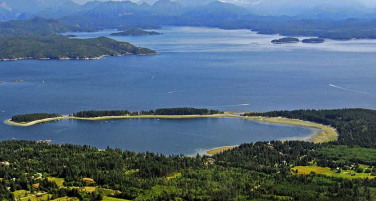
Quadra island s rebecca spit provincial marine park 136 minutes from living forest
Quadra Island is an island off the eastern coast of Vancouver Island, British Columbia, Canada, part of the Discovery Islands located within the Strathcona Regional District. Quadra Island is about 35 kilometres (22 miles) from its northernmost point to its southernmost point. The island at its narrowest point, on its southern peninsula, is less than 2 km (1.24 mi) wide, and at its widest point, about 15 km (9 mi) wide. In area Quadra island comprises about 310 square kilometres (120 square miles). The population of island and surrounding mainland inlets, as of the 2006 federal census (excluding First Nations Reserves, tallied separately), was 2,472, down from the 2001 federal census count of 2,548. In 1903 it was named after the Spanish navigator Juan Francisco de la Bodega y Quadra, who explored and settled the Vancouver Island area in the late 18th century. It is separated from Vancouver Island by Discovery Passage, and from Cortes Island, and is linked to that island by a ferry from Heriot Bay on its eastern shore. The island has many beaches, trails, lakes, and parks. Main Lake Provincial Park is located on the northern part of the island, and Rebecca Spit Marine Provincial Park is on the eastern shore, near Heriot Bay.
Contents
- Quadra island s rebecca spit provincial marine park 136 minutes from living forest
- Map of Quadra Island British Columbia Canada
- References
Map of Quadra Island, British Columbia, Canada
Few of the island's soils are well suited to agriculture. Most are coarse and, in well-drained areas, have classic podzol profile development; they are mapped as Kye loamy sand and Quinsam gravelly sandy loam. A small area of dark well-drained unpodzolized soil (Lazo loamy sand) is mapped around the southeast corner. Dashwood gravelly loamy sand, a brown podzolic trending to podzol, is commonly associated with Kye and Quinsam. Imperfectly drained areas have brown podzolic Bowser loamy sand or classic podzol Sayward loamy sand. The more moist Custer loamy sand is present locally. Poorly drained areas have Arrowsmith peat, Parksville sandy loam, or Tolmie loam (the latter two are gleysols).
There are two small business centres on the island, one near the Vancouver Island BC Ferry terminal at Quathiaski Cove, and one near the Cortes Island ferry terminal at Heriot Bay. The island is home to a thriving art community, as well as a growing number of white-collar professionals who commute to Campbell River on Vancouver Island.
There is an elementary school on the island. Schoolchildren in grades 6–12 travel by ferry to Campbell River to attend École Phoenix Middle School or Carihi Secondary School. The Cape Mudge Reserve on the southern tip of the island is home to the We-wai-kai, one of the main bands comprising the Southern Kwakiutl (the other being the We-wai-kum based in Campbell River on Vancouver Island). Together they are known as the Laich-kwil-tach (historically known as the Euclataws or Yucultas, names more familiar to speakers of British Columbia English). The Nuyumabalees Cultural Centre is located within the Cape Mudge Village and holds an important collection of art from earlier times, items that were repatriated after many years from museums elsewhere.
The Southern Kwakiutl (part of the larger Kwakwaka'wakw ethnic grouping) migrated into the northern Georgia Strait from Queen Charlotte Strait over two centuries ago, displacing and absorbing the Comox and Pentlatch peoples who formerly lived there.