
Isolation 2.09 mi (3.36 km) First ascent 1909 Parent peak Maroon Bells | Elevation 4,275 m Prominence 493 m | |
 | ||
Topo map USGS 7.5' topographic mapMaroon Bells, Colorado Easiest route Exposed scramble, class 4 Similar Capitol Peak, Castle Peak, Snowmass Mountain, Elk Mountains, Crestone Needle | ||
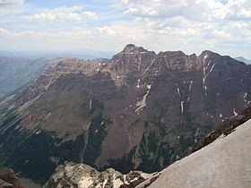
Pyramid Peak is a fourteen thousand foot mountain in the U.S. state of Colorado. It is the 47th highest mountain peak in Colorado, and 78th highest peak in the United States. It is located in the Elk Mountains in southeastern Pitkin County, approximately 12 miles (19 km) southwest of Aspen. The summit somewhat resembles a ragged square pyramid and is visible from the Roaring Fork River valley north of Aspen along the canyon of Maroon Creek.
Contents
Map of Pyramid Peak, Colorado 81611, USA
Like many of the peaks in the Elks, Pyramid Peak is quite steep, especially compared to more gentle fourteeners such as Mount Elbert. For example, the peak's summit rises 4,000 feet (1,200 m) above Crater Lake to the northwest in only 1.2 miles (1.9 km), and 4,400 feet (1,300 m) above East Maroon Creek to the east of the peak in the same horizontal distance.
ClimbingEdit
The standard climbing routes on Pyramid Peak are the northeast and northwest ridges (the latter is also known as the "Keyhole Route"). These routes involve difficult route finding (very difficult, in the case of the northwest ridge), high exposure, and a great deal of loose rock. Hence they are two of the most difficult and dangerous of all of the standard routes on the Colorado fourteeners.